Precipitation
Overview
If precipitation did not fall over land, plant or animal life would not have enough freshwater to survive. Condensation on cold surfaces at night (dew) aids land plants, but there isn’t enough water to continually support them throughout a growing season. Water is in a gaseous form in the atmosphere as water vapor and in liquid and solid forms in clouds. Cloud droplets and crystals are so small they remain suspended in the atmosphere for long periods due to gentle turbulence. In still air, a cloud droplet would take roughly 10 hours to fall 500 m. On average, a liquid raindrop has a million times more water molecules than a cloud drop, so how do the cloud drops grow that big?
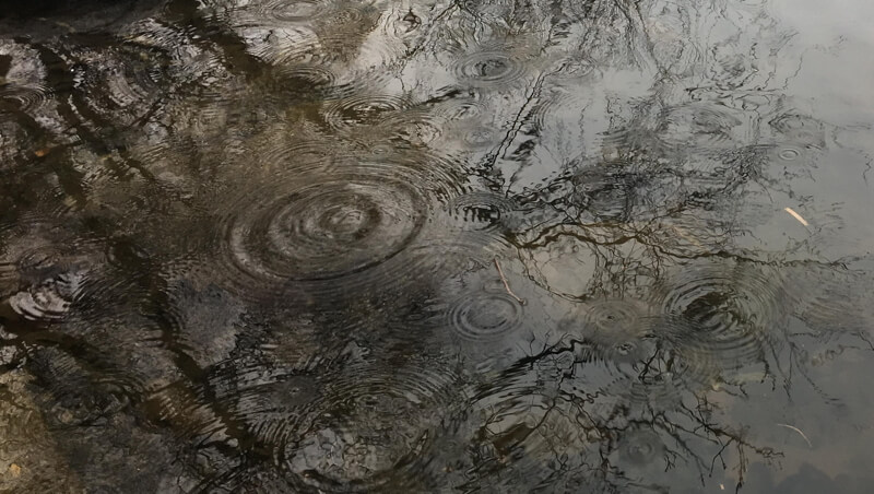
In clouds with temperatures > -15ºC (5ºF), liquid droplets grow by bouncing into each other and merging (called collision and coalescence). When both liquid droplets and ice crystals are present in colder clouds, the ice crystals grow at the expense of the evaporating liquid droplets (for details, see Roland Stull’s free online book). In either process, once the liquid droplet or ice crystal is too heavy to remain aloft, it falls to create precipitation. But what type will it be when it reaches the ground?
Types of Precipitation
There are many types of precipitation, and most depend on the form of water falling from the sky, but some also depend on the rainfall intensity and the size of the drops. Below are the names of rain based on intensity and droplet size.
|
Intensity in/hr (cm/hr) |
Median Diameter (mm) |
Fall Velocity ft/s (m/s) |
Drops Per Second Per Unit Area s/ft² (s/m²) |
|
|
Drizzle |
.01 (0.025) |
0.96 |
13.5 (4.1) |
14 (151) |
|
Light rain |
.04 (0.10) |
1.24 |
15.7 (4.8) |
26 (280) |
|
Moderate rain |
.15 (0.38) |
1.60 |
18.7 (5.7) |
46 (495) |
|
Heavy rain |
.60 (1.52) |
2.05 |
22.0 (6.7) |
46 (495) |
|
Excessive rain |
1.60 (4.06) |
2.40 |
24.0 (7.3) |
76 (818) |
|
Cloudburst |
4.00 (10.2) |
2.85 |
25.9 (7.9) |
113 (1,220) |
From the USGS Water Science School.
Precipitation reaching the ground has various forms based on whether they are liquid, solid, or turn from liquid to solid upon contact with the ground. In the tropics, nearly all precipitation is in the form of rain, but at higher latitudes, most precipitation started as snow near the top of the cloud and melted as it fell through the warmer air below.
Freezing Rain: precipitation that falls in liquid form but freezes upon impact to form a glaze coating upon the ground and on exposed objects.
Graupel: forms when supercooled water droplets freeze onto falling snowflakes
Hail: balls or irregular lumps of ice produced by convective clouds, nearly always cumulonimbus.
Ice Pellets (Sleet): transparent or translucent pellets of ice, less than 5 mm in diameter. They may be spherical, irregular, or (rarely) conical in shape.
Snow: white or translucent ice crystals in complex branching hexagonal form.
Snow Grains: very small, white opaque particles of ice; the solid equivalent of drizzle.
Definitions are from the American Meteorological Society’s online glossary of terms.
Celebrate the Arrival of Spring Showers: Make it Rain Indoors!
An annual celebration we did just before the arrival of spring was to make it rain at our school:
- Rub your hands together to make it breezy.
- Snap your fingers together to make drizzle.
- Slap your hands on your thighs to make it rain.
- Keep slapping your hands on your thighs and stomp your feet to make heavy rain.
- Reverse the order as the rain shower passes.
Ingredients for Precipitation
There are three key ingredients to make precipitation:
- Source of water at the surface to supply water vapor to the atmosphere through evaporation and/or evapotranspiration.
- Clouds: It may sound obvious, but rain does not occur in clear skies. There need to be small cloud drops and/or ice crystals first, and these are what grow into raindrops or snowflakes.
- Rising air: It is extremely rare for precipitation to form in fog, rather rising air expands, cools, and once condensation occurs, positive feedback can occur where air continues to rise, allowing for more condensation and ultimately the growth of cloud droplets/ice crystals.
There are four common mechanisms that create rising air:
- Convergence of surface winds.
- Wind pushing air up a mountain.
- Heating of the surface air, and
- Combination of the above.
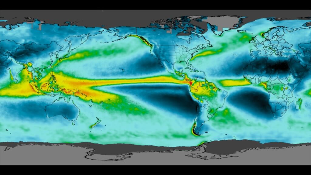
This IMERG Grand Average Climatology image shows the average amount of precipitation that falls in the world each year (mm/year), computed from June 2000 – May 2019. Image from NASA’s Scientific Visualization Studio.
Where Does It Precipitate Most?
So, where do the ingredients for precipitation occur most consistently? The tropics, and this is where it rains most!
Why?
- There is a large extent of warm ocean water in the tropics.
- When a large continent straddles the Equator, the evapotranspiration of water vapor from the tropical rainforests supplies a great deal of the water vapor for rain over the region.
- Global circulation cells create large-scale convergence of surface winds and upper-air divergence for a near-continuous zone of precipitation (often referred to as the Intertropical Tropical Convergence Zone or ITCZ). It is highlighted in the NASA IMEG image above in yellows to reds.
But it is not constantly raining in the tropics. Most tropical regions have wet and dry seasons. As the ITCZ moves over the region, the wet season begins, and the dry season begins when it moves away.
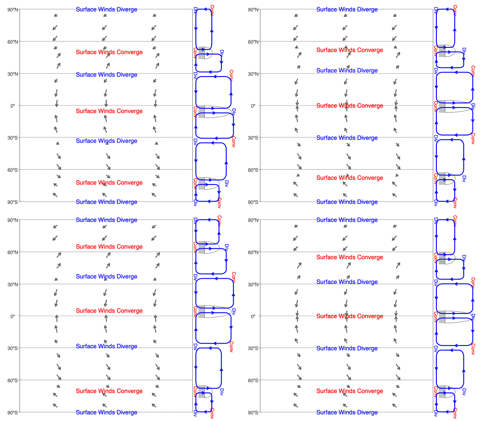
This animation shows how the tropical zone of surface wind convergence meanders above and below the Equator throughout the year as it moves with the solar declination.
Diurnal Heating and Precipitation
Satellite imagery has changed our understanding of global precipitation patterns, in part, over the vast ocean regions of Earth. As shown in Variables Affecting Diurnal Heating, water, land, and vegetation have different reflectivities, values of specific heat, and density, which affect the magnitude and timing of heating and cooling throughout the day. When precipitation is caused by heating of the surface air (rather than due to the other mechanisms described earlier), we need to consider these differences in the surface heating and cooling on the timing of precipitation events, as illustrated in the following animation. For additional examples, visit NASA’s Precipitation Climatology.
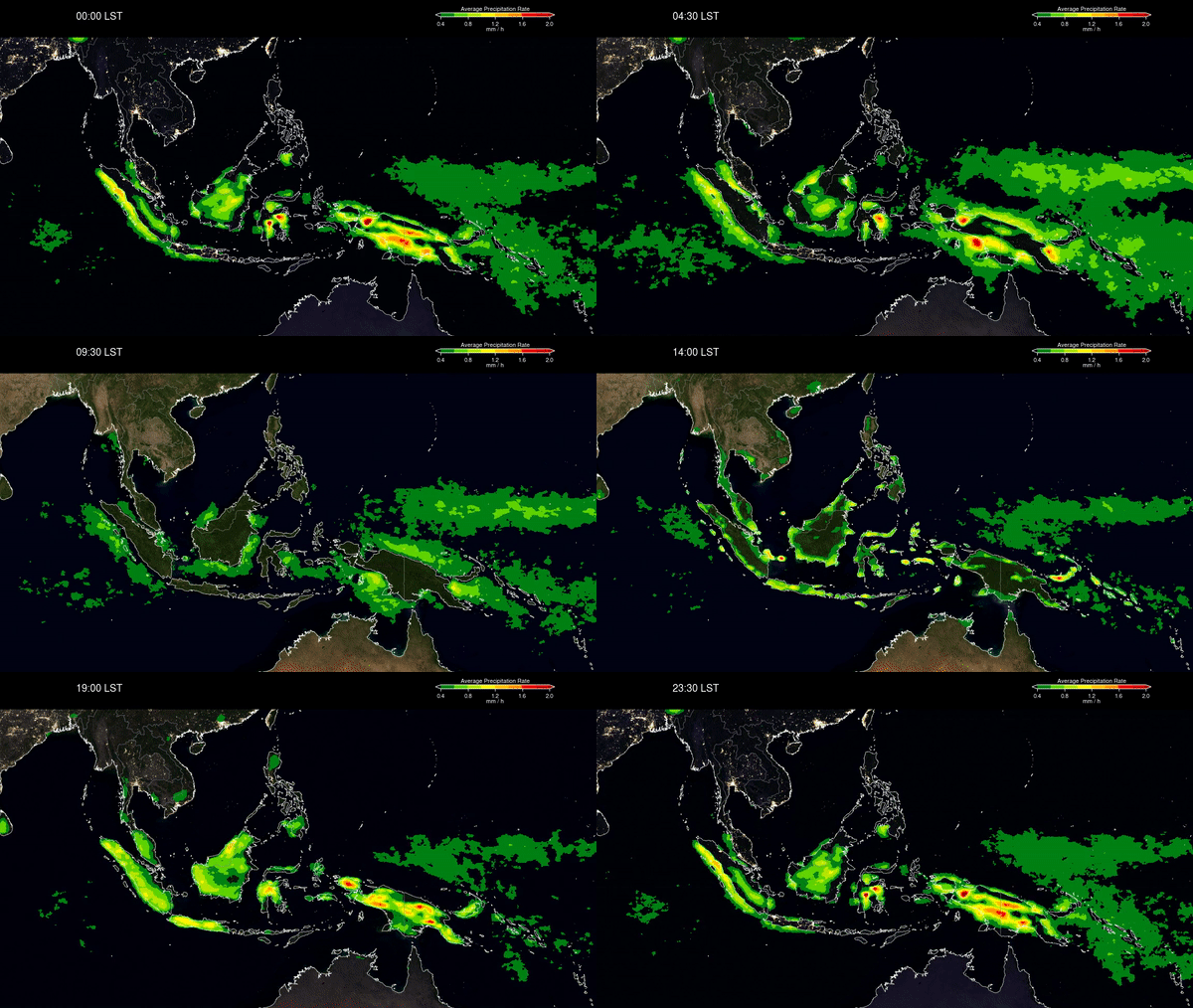
Animation showing the complex effect of diurnal heating on tropical precipitation in the South China Sea. Thunderstorms form in the afternoon near the coast but later in the evening further inland. Over the ocean, the precipitation reaches a peak at about midnight over the coastal waters but later in the morning in the open ocean. Animation from NASA’s Scientific Visualization Studio.
Persistent Precipitation Forms Deserts Downwind
If air rises from the ground, forms a cloud and then sinks back to the ground without any precipitation falling from the air, the air will have the same temperature and water vapor content that it started with. But if water leaves the air as precipitation at any time during its ascent or descent, much of the latent heat of condensation remains within the air and there is less water to evaporate as the air sinks to the ground. This creates warmer and drier air reaching the ground compared to the air when it left the ground originally. If this downwelling of warm dry air remains consistent over a region with time, a desert forms. Looking at the animation of global circulation cells above, persistent downwelling of air that lost precipitation in the tropics occurs at roughly 30º north and south of the equator. Notice the bands of desert on the continents that are centered on 30ºN and S.
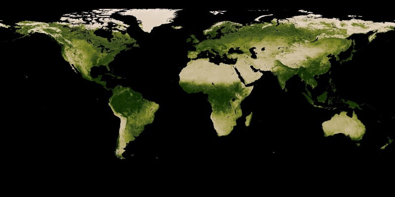
Above is a map of the average annual vegetation on land (the darker the green, the greater the vegetation). Deserts appear light brown. Image is from My NASA Data annual vegetation changes.

0 Comments