
Winds Around a Low-Pressure Center
There are two significant differences between the examples on Winds and Balanced Forces and the ones on this page:
1) There was only one wind used with the straight isobars (lines of constant air pressure), representing a single latitude. With low-pressure centers, there is a physical size to them, so latitude changes with location.
In the examples below, the outer winds are 500 km from the center. One degree latitude equals 111 km, so the distance between the northernmost wind and the southernmost is 9º latitude.
The magnitude and direction of the Coriolis force depend on the latitude, so Coriolis force is not uniform across the low-pressure system.
2) Winds tend to spiral into the center of the low-pressure system, so they curve and experience centrifugal force. Now we are dealing with four forces acting on the moving air: pressure gradient force, friction, Coriolis force, and centrifugal force.
In each of the animations that follow, data for the location at the bottom position is output. The site has a yellow circle around it. This point isn’t always the southernmost point. When the center latitude is 90ºS, its latitude is 85.5ºS, which is to the north.
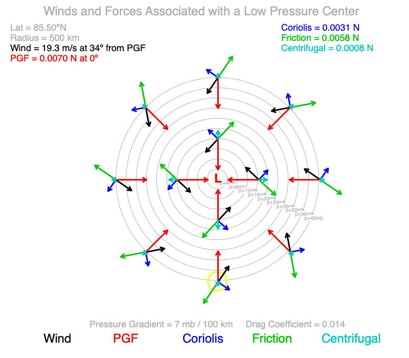
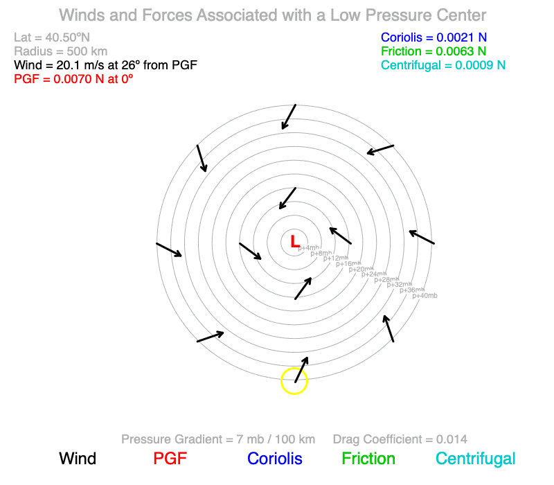
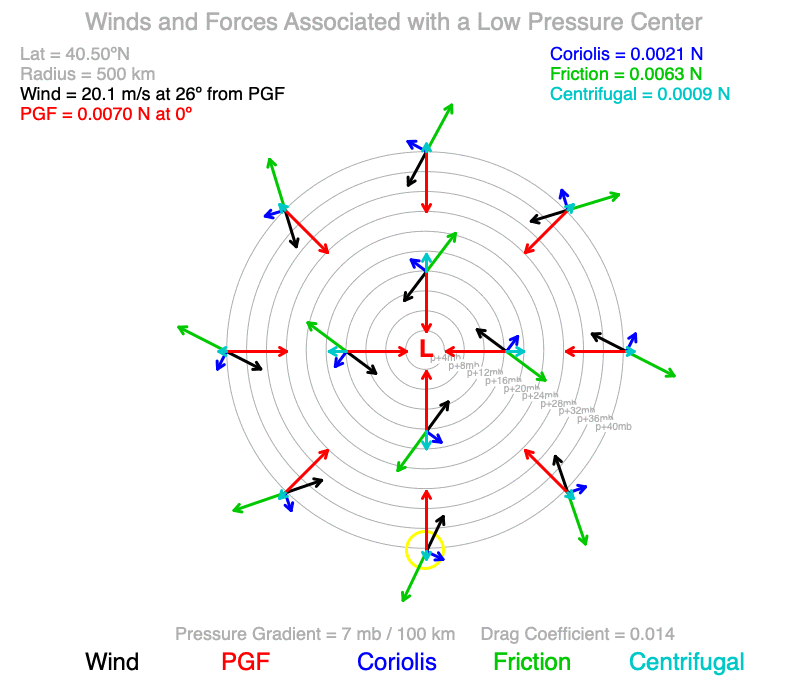
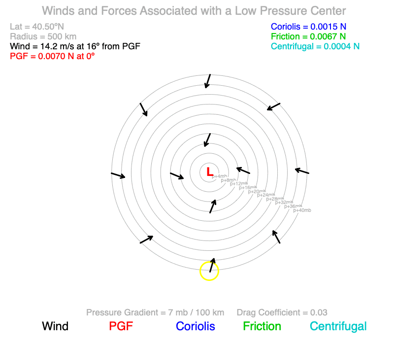
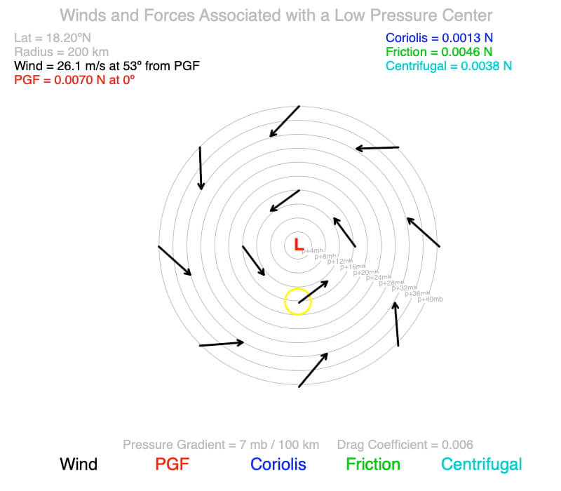
Effect of Coriolis Force (Latitude)
The pressure center’s latitude starts at 90ºN and changes in 10º increments southward. The pressure gradient is 7 mb / 100 km toward the center, and the drag coefficient represents a forest creating friction with the moving air.
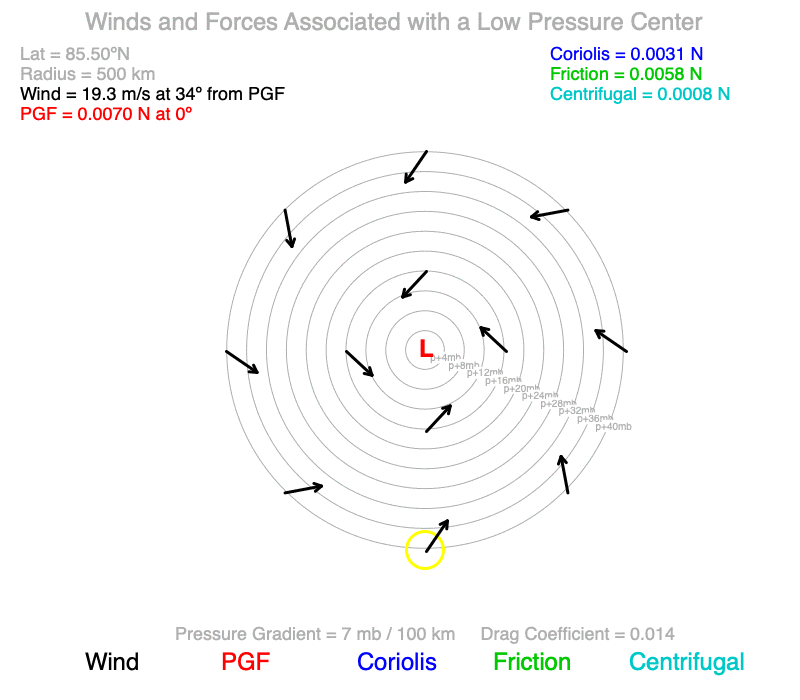
What patterns do you observe as latitude changes?
The angle the winds cross the isobars is called the cross-isobar angle.
1) The cross-isobar angle increases as the latitudes approach the Equator (0º), so the winds flow more directly toward the center.
2) Winds spiral counterclockwise toward the low-pressure center in the Northern Hemisphere and clockwise in the Southern Hemisphere.
3) Winds near the center are slower than the winds further from the center.
4) The cross-isobar angles are not constant across the low-pressure system. The winds closest to the center are deflected further from the pressure gradient (remember, always perpendicular to the isobars) than the winds further from the center.
5) Something odd is happening when the latitude of the pressure center is at the Equator (0º). Winds at 0º could not be calculated mathematically. Notice that the winds in the Northern Hemisphere (the upper half of the image) are turning counterclockwise, and the winds in the Southern Hemisphere (bottom half) are turning clockwise.
What cause these patterns?
1) The cross-isobar angle increases as the latitudes approach the Equator (0º) since lower latitudes have smaller values of Coriolis force for given wind speed. There is less turning away from the pressure gradient at lower latitudes.
2) Winds spiral in opposite directions north and south of the Equator because the Coriolis force is perpendicular to the right of the wind in the Northern Hemisphere and to the left in the Southern Hemisphere.
3) Winds near the center are slower than the winds further from the center because the winds turn more toward the center of the low. The tighter the turn, the higher the outward acting centrifugal force, which offsets a portion of the inward-directed pressure gradient.
4) Friction and Coriolis force are both proportional to wind speed, but friction decreases more as wind speed decreases. Since centrifugal force increases toward the center of the low-pressure center (see #3), the wind speed decreases, and friction decreases more than the Coriolis force. The cross isobar angle decreases toward the low-pressure center since there is proportionately more force turning the wind away from the pressure gradient.
5) When a low-pressure center is at or near the Equator, winds in the Northern Hemisphere are deflected to the right of the pressure gradient and those in the Southern Hemisphere to the left. Winds are no longer spiraling around the low-pressure center.
Effect of Pressure Gradient
The pressure gradient begins at 7 mb / 100 km toward the center and decreases in 0.5 mb / 100 km increments. The pressure center’s latitude is 45ºN, and the drag coefficient is representative of a forest creating friction with the moving air.
What patterns do you observe as the pressure gradient decreases??
The angle the winds cross the isobars is called the cross-isobar angle.
1) The cross-isobar angle decreases as the pressure gradient weakens.
2) Wind speed decreases at the pressure gradient decreases.
3) Winds near the center are slower than the winds further from the center.
4) The cross-isobar angle for the winds closest to the center are less than for the winds further from the center.
What cause these patterns?
The angle the winds cross the isobars is called the cross-isobar angle.
1) The cross-isobar angle decreases as the pressure gradient force weakens since friction decreases more than the Coriolis Force, so there is more turning away from PGF.
2) Wind speed decreases at the pressure gradient decreases since there is less push to get the air to move.
3) Winds near the center are slower than the winds further from the center since the radius of curvature is higher, which increases the centrifugal force that offsets a portion of PGF. Remember, the centrifugal force and PGF are perpendicular to the isobars, but they are in the opposite direction from each other.
4) The cross-isobar angle for the winds closest to the center are less than for the winds further from the center, which is also a result of the centrifugal force offsetting the PGF, and friction decreases more than the Coriolis force.
Effect of Friction (Drag Coefficient)
In these animations, the drag coefficient, which characterizes the roughness of the surface interacting with the wind) decreases from 0.03 (a heavily forested mountain) to 0 (no friction). The pressure gradient across the area is 7 mb / 100 km, and the low-pressure center’s latitude is 45ºN.
What patterns do you observe as friction decreases?
The angle the winds cross the isobars is called the cross-isobar angle.
1) The cross-isobar angle decreases as the drag coefficient decreases (friction decreases). When frictionless, the winds are parallel to the isobars, so they are not converging toward the low-pressure center.
2) Wind speed increases as friction decreases.
3) Winds near the center are slower than the winds further from the center.
4) Except for the frictionless case, the cross-isobar angles for the winds closest to the center are less than for the winds further away.

What cause these patterns?
1) When friction is zero, the Coriolis and centrifugal forces must balance the pressure gradient force. Since the centrifugal force opposes the pressure gradient force, Coriolis bends the wind, so the sum of the Coriolis and centrifugal forces are equal and opposite the pressure gradient force. Since Coriolis is always perpendicular to the wind, the wind is parallel to the isobars.
2) Since friction opposes the motion of the wind, when there is less friction, there is more acceleration by the pressure gradient.
3) Winds near the center are slower than the winds further from the center since the tighter turning of the wind creates more centrifugal force, which opposes the pressure gradient. There is less net force to accelerate the wind closer to the center of the low.
4) Friction decreases more than Coriolis force as wind speed decreases (see #3). There is a higher amount of force to turn the wind away from the pressure gradient as the wind approaches the center of the low.
Role of Centrifugal Force on Low-Pressure Systems
Low-pressure centers create storms (see the Clouds section), and we tend to think of storms with strong winds. But centrifugal force actually slows the winds toward the center of the storm!
The centrifugal force also affects wind direction as air flows toward the center of a low (see the examples of the low-pressure systems centered at 10, 20, and 30ºN below). This creates a broader region of converging surface wind as storms form further from the Equator. This will be important to think about when exploring the Clouds and Precipitation sections.
Hurricanes and Latitude
Hurricanes (called typhoons in the Eastern Hemisphere) basically have circular isobars surrounding the low-pressure center. Interestingly, they don’t form within 3º of the Equator. Why?
A hurricane takes up space, so latitude changes from the northern tip to the southern. When close to the Equator, part of the low-pressure region will be in the Southern Hemisphere, and part in the Norther. The changing direction of the Coriolis force acting on the wind doesn’t allow the winds to spiral into the center of the low, which is an essential ingredient for a hurricane to form (see the example of a low-pressure center at 1ºN). There is enough room for this spiral flow to form by roughly 3º N or S.
As hurricanes move away from the Equator, Coriolis force increases proportionately for a given wind speed. As winds flow toward the center of the low, they are deflected away from the pressure gradient more and more (see the examples of lows at 10, 20 and 30ºN). Hurricanes tend to grow in size as they move to higher latitudes.

A low-pressure center located at 1ºN. A bit more than half of the system is above the Equator, and the rest is south.

Low-pressure center located at 10ºN. The drag coefficient has been reduced to levels that are found over the oceans.
Low-pressure center located at 20ºN. The drag coefficient has been reduced to levels that are found over the oceans.

Low-pressure center located at 30ºN. The drag coefficient has been reduced to levels that are found over the oceans.
Continue to Explore Winds
Use the desktop app, Earth, Wind, and Forces, to explore winds moving around low-pressure centers on Earth. Go to the Software page to download a version for Macs or PCs.
0 Comments