
Earth’s Illumination Patterns
The Sun illuminates the spherical, rotating planets orbiting it. A person on Earth perceives the Sun’s movement just as a person sitting in a moving car, train, or plane sees the landscape passing by. With each rotation of our planet, we see the Sun and stars move across the sky in a circular path. The apparent location of the Sun and stars in our sky depends on how our horizon is oriented with respect to these celestial bodies. Recall from Earth’s Coordinate System that we are using the astronomical horizon: the horizontal plane that is perpendicular to the observer’s zenith (the point directly above the observer), and we will refer to the view above our horizon as our local sky.

A person is always located in the center of their horizon (shown in green), and the zenith (labeled “z” in the diagram) is located directly overhead in one’s local sky (shown in light blue).
Earth spins about its axis of rotation (shown as the red lines in the following animation), which we use to define our latitudinal coordinates (shown every 30º as blue lines). The North and South Pole, at 90º N and S respectively, are located on the axis, and all latitude circles are centered on our rotational axis, which makes them parallel to each other.
The orientation of the horizon (shown as a green line) relative to the axis of rotation is determined by one’s latitude. At the Equator, the horizon is parallel, and at the poles, it is perpendicular to the axis.
The Earth’s rotation changes the orientation of our horizon and local sky (shown as a blue dome when in daylight and a gray dome when not) to the Sun throughout the day.
Click the button to run the web app designed for desktops, laptops, and tablets.
Explore the illumination patterns on Earth at different latitudes and two times (local noon and midnight) throughout the year using the Sun and Your Horizon web app.
Acknowledgments Alan Gould and Matti Horne provided invaluable suggestions that improved this app.

In the Sun and Your Horizon web app, the Sun is shown on the left in orange, the illuminated Earth in a light yellow, and the dark half of Earth in gray. The Earth’s axis of rotation is shown by the red lines. Latitude circles are shown as blue horizontal lines, longitude as curved vertical lines, the horizon (one at local noon and the other at local midnight) as green lines, the black line denotes the location of an observer’s zenith, and local sky as domes of either blue or gray depending on if illuminated or not.
Earth’s Orbit Viewed From the Side
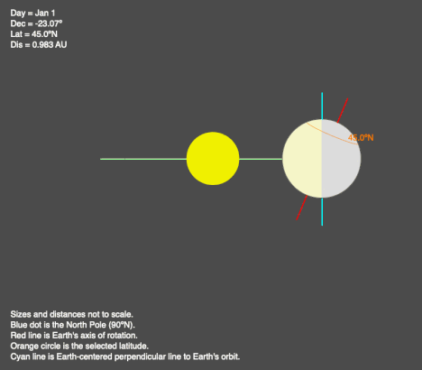
Animation of Earth’s orbit when viewed from the plane of the orbit. In these images, the red line is the Earth’s axis of rotation and the cyan line/’x’ represents the line going through Earth’s center that is perpendicular to its orbital plane. The reference latitude shown in orange is 45ºN.
Earth’s Illumination during an Orbit from an Earth-centered Perspective

Earth is on average 93 million miles from the Sun, so the Sun’s rays are parallel to each other as they reach Earth. Therefore, the angle the sunlight hits the ground depends on the orientation of the horizon relative to the axis of rotation (so the latitude) and the orientation of the rotational axis to the Sun (so the day of the year).
Finally, the orientation of the Earth’s axis of rotation to the Sun depends on where we are in our orbit (or the day of the year). Our axis of rotation is not perpendicular to our orbital plane, so the illumination of the Northern and Southern Hemispheres changes during the course of our orbit (shown in the previous animations).
The Earth’s Illumination Patterns section explores the illumination of an orbiting, rotating sphere from three perspectives:
-
- Location of the Earth in its orbit around the Sun,
- Above the Earth so half of the planet is seen at any given time, and
- While viewing a given location either from the horizon or directly above the location.
Each of these visualizations helps explore how the Earth’s orbital, rotational, and shape parameters determine our planet’s daily and seasonal illumination patterns.
Big Ideas
- The Sun’s energy heats the Earth unevenly to create its night/day heating patterns, seasons, and climate regimes, all of which maintain atmospheric and ocean currents.
- Earth’s orbit, rotation, and shape create the heating patterns.
Click on the following toggles to view descriptions and links of the web pages on each topic of the Sun-Earth Connection.
Sun-Earth Connection overview
An overview of how the Sun’s energy is generated and how its thermal radiation illuminates and heats Earth.
Earth Illumination Patterns
- Overview: The Sun illuminates the spherical, rotating planets orbiting it.
- Obliquity and Earth’s Illumination: Obliquity is the angle between the planes of the Earth’s equator and its orbit around the Sun.
- Declination, Latitude, & Earth Illumination: Solar declination is the angle between the Sun’s rays and the plane of the Earth’s Equator. Its value depends on where Earth is in its orbit around the Sun.
- Astronomical Seasons & Illumination: Astronomical seasons are based on the orientation of Earth’s axis of rotation to the Sun, which determines the amount of illumination between the Northern and Southern Hemispheres.
Distribution of the Sun's Energy on Earth
- Overview: Even though an area is illuminated by sunlight, there can be quite a range of energy interacting with the surface.
- Sun Angle and Beam Concentration: If every beam of sunlight reaching Earth has the same amount of energy, why do some areas warm up more than others?
- Diurnal Heating: Diurnal heating is the temperature change over 24 hours. When sunlight shines on the ground, it warms. Two critical factors that determine the amount of heating deal with the Sun’s illumination.
- Seasons: Earth experiences astronomical seasons due to its obliquity.
- Climate Regimes: Climate regimes are an extension of diurnal heating and seasons, but the time frame is now years.
Declination Circles: A tool to analyze the Sun's position in the sky.
- Overview: Drawings of declination circles contain the visual and numerical information to understand and predict the Sun’s motion across the sky.
- Declination Circles 101: Draw a declination circle with just a ruler and protractor/compass to quickly and accurately know the Sun’s position in the sky at any day and time of the year for any location on Earth.
- Drawing Declination Circles: Declination circles are quite easy to draw by hand.
- Interpreting Time on Declination Circles: Accurately estimate the time of day using the Sun’s location in the sky.
- Sunrise, Sunset, & Twilight: Calculate the timing and duration when the Sun is at or near the horizon.
- Solar Time, Angle, & Position: The sun’s angle and direction to the local horizon define the Sun’s position in the local sky. Explore how to use declination circles to calculate the Sun’s position at any solar time anywhere in the world on any day of the year.
- Changing Views of Declination Circles: Use the web app View Declination Circles to explore three common views of declination circles to identify their strengths, limitations, and applications. Then learn how to go from one view to another.
- Using Declination Circles: Humans have been using the apparent motion of the Sun as a compass, clock, and calendar for millennia.
- Using Sundials: Humans have been using the Sun’s position to navigate and tell the time, day, and season for millennia. Sundials create shadows that make it easier to do these tasks.
0 Comments