
Clouds in Nature
What Causes Rising Air?
Rising air creates clouds, so what causes the air to rise? Three basic mechanisms lift air parcels from the surface to higher altitudes:
- buoyancy,
- mechanical lifting, and
- the convergence of surface winds and/or divergence of upper-level winds.
Clouds form in rising air and evaporate in sinking air.
Buoyancy
Buoyancy is the force acting on an object immersed in a fluid. Air parcels immersed in the atmospheric gases experience buoyancy. The magnitude of the buoyant force pushing upward on an air parcel is equal to the weight of the gases it displaces.
The direction an air parcel moves depends on the density of the parcel compared to its surroundings:
- If the weight of the air parcel is greater than the buoyant force acting on it (or the density of the air parcel is higher than the density of the surrounding air), the air is negatively buoyant sinks or stays at the ground.
- If the weight and buoyancy are equal, or the densities are equal, the neutrally buoyant parcel remains at the same level in the fluid.
- A positively buoyant air parcel is less dense than its surroundings and will rise until it becomes neutrally buoyant with the surrounding air.
Hot air balloons rise, cold air balloons sink. Heating the air at the ground so it becomes less dense than its surroundings (positively buoyant) and rises.
Effect of Surface Heating
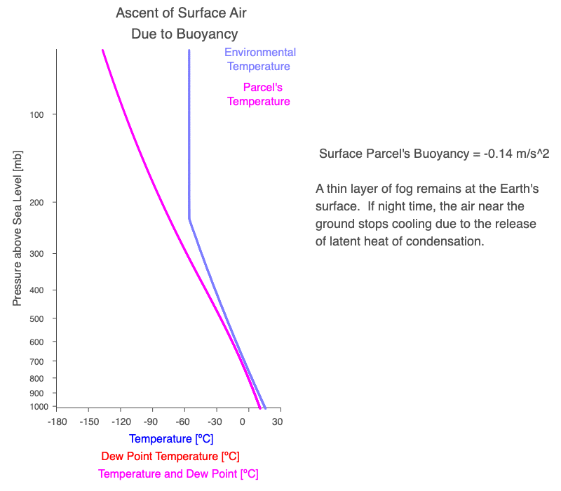
Above is an example of surface air warming either due to daytime heating or the air moved over a warmer surface. Once the air becomes warmer than the surrounding air, it rises to an elevation where its temperature equals the surrounding’s.
If a cloud forms as the air parcel rises, the latent heat of condensation warms and expands the parcel, decreasing its density. Depending on the environmental lapse rate (light blue), the parcel’s altitude where it becomes neutrally buoyant will increase.
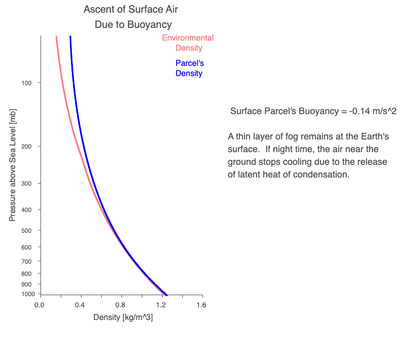
Above is the same scenario of surface air warming, but now the density profile of the surrounding air and the air parcel as it rises are plotted. Once the air at the surface becomes less dense than the neighboring air, it rises to an elevation where its density equals the surrounding’s.
Notice that when a cloud forms, it isn’t thin; instead, it is a tall or ‘building’ cumulus cloud. The vertically-extensive cumulus cloud indicates that for this environmental lapse rate (light blue), the altitude where the parcel becomes neutrally buoyant is quite high.
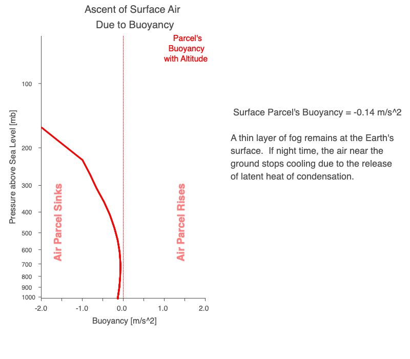
The same example of surface air warming, but now with the buoyancy profile plotted. Once the air became positively buoyant (less dense than its surroundings), it rises to an elevation where it is neutrally buoyant. The dotted red line is zero buoyancy (or neutral). To the left of the dotted lines are negative buoyancies, and to the right are positive values.
Afternoon summer-time thunderstorms or convective showers are often a result of surface air warming during the day and, once buoyant enough, rising to the top of the troposphere.
Effect of Evaporating Water at the Surface
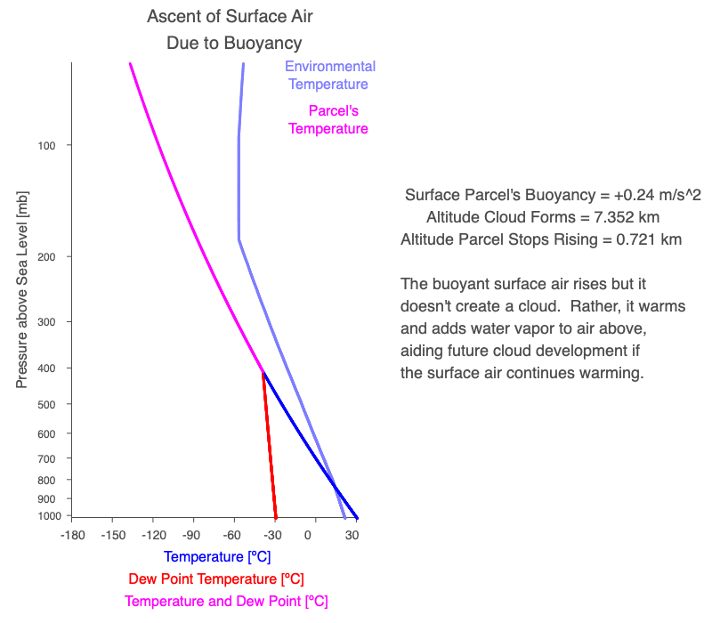
Above is an example of warm surface air gaining water vapor as it moved over a body of water. The air already warmer than the surrounding air, but it was too dry to create a cloud as it rose before becoming neutrally buoyant. Once there is enough water vapor to produce a cloud, the added latent heat of condensation allows the saturated air to rise even higher in the atmosphere.
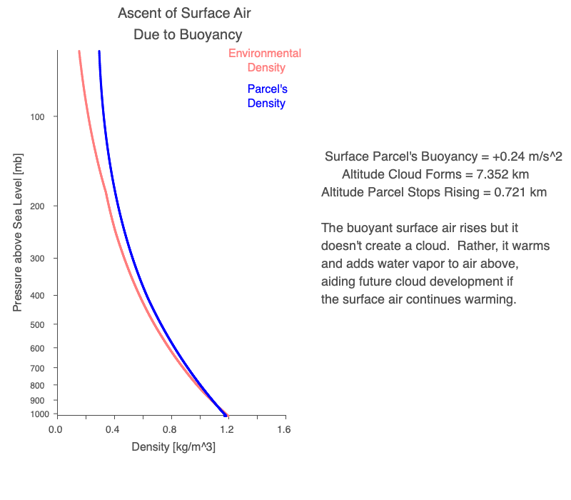
The same scenario of warm surface air gaining water vapor, but now the density profiles of the environment and the rising parcel are displayed.
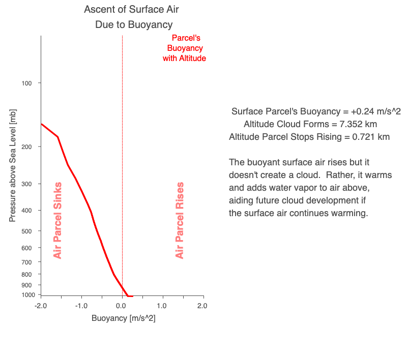
The same scenario of warm surface air gaining water vapor through evaporation, but now the vertical buoyancy profile is displayed.
In the late fall, when cold air moves over a large body of water that is still warm (remember water has a very high specific heat, so it cools very slowly), the surface air warms and then evaporates more water, creating the lake effect snows.
Mechanical Lifting
Mechanical lifting is when wind pushes air into a denser object, such as a mountain. Air rises upslope. Once at the top, if the air is negatively buoyant, it flows down the mountainside.
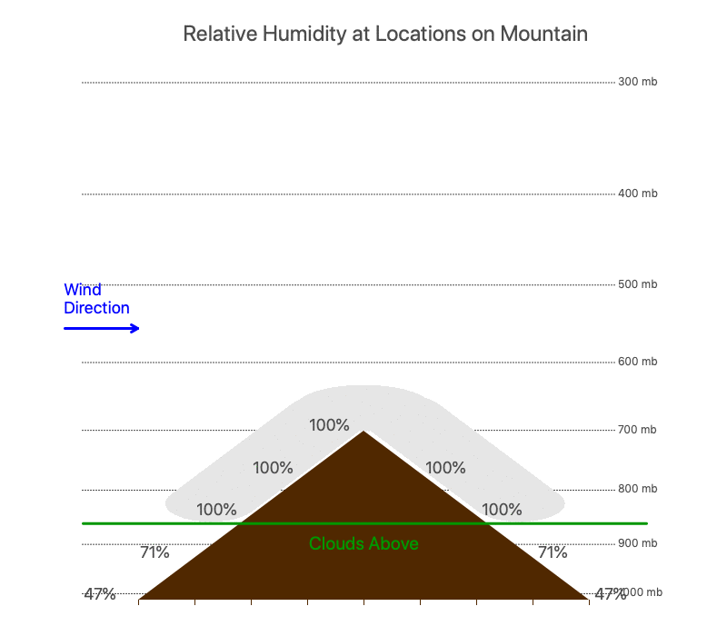
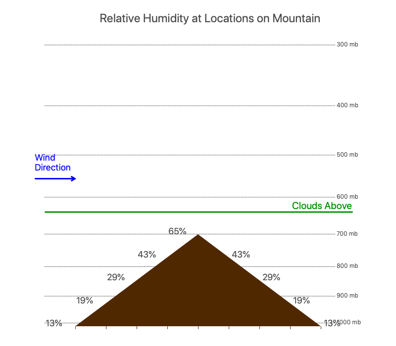
In the animations that follow, the wind is blowing from left to right across the mountain. The dotted lines show the air pressure with height, and the numerical values on the mountain are the relative humidities of the air at the corresponding altitude. If a cloud forms, it is highlighted in light gray.
Wind pushes air up a mountain. This is orographic lifting and is one type of mechanical lifting.
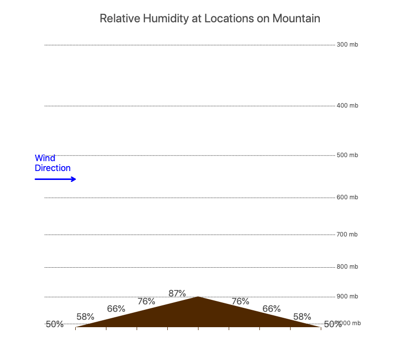
Air at the base of the mountain is 50% (temperature of 15ºC and dewpoint temperature of 5ºC), but this won’t create a cloud at the peak of all hills. In this case, only ones that are taller than 1.3 km.
Often the dewpoint temperature doesn’t change much during the daytime, but the temperature does. You might start your morning hike up the mountain with the peak covered by clouds, but by the time you arrive at the summit, it could be cloud-free.
If the surface air gains more water vapor through evaporation, the elevation that clouds form decreases.
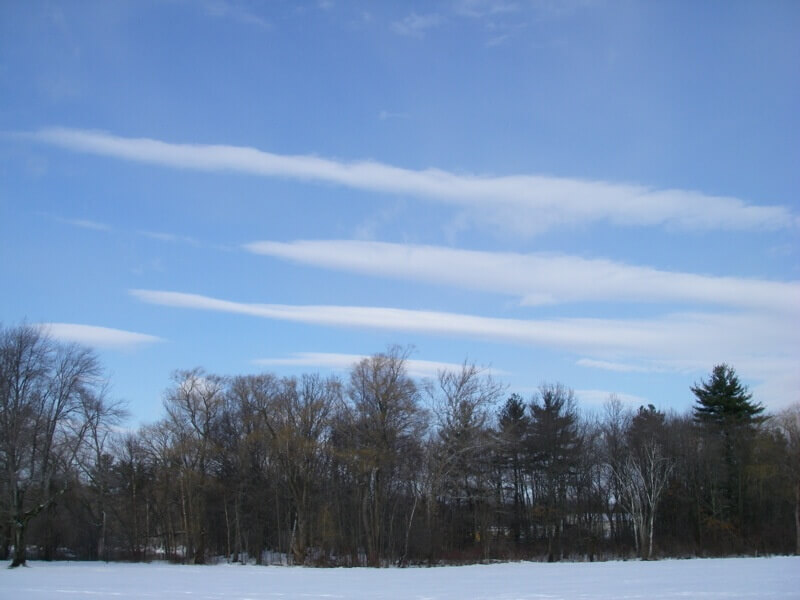
Lenticular Clouds
The examples above make it seem the clouds must be at or lower than the mountain/hill peak. But they don’t. Flowing air is pushed up even above the obstruction so that lenticular clouds may form in the rising part of the wind.
Lenticular clouds formed over the hills of eastern Massachusetts one cold and windy day.
Convergence and Divergence
If surface winds converge into an area, the air is pushed upward. Similarly, if the upper-level winds diverge from, there is less air pushing down on the column of air, creating low pressure at the surface and convergence of surface winds.
The Sun’s heating patterns on Earth’s rotating spherical surface create persistent low-pressure bands near the equator, 60ºN, and 60ºS (see Earth, Wind, and Forces for details), and high-pressure regions at the poles, 30ºN, and 30ºS. These create global wind circulation cells that persistent zones of low-level convergences and divergence (see the animation on the right).
Hurricanes are also driven by the convergence of surface winds and upper-level divergence. These are warm water engines, where water vapor is the fuel. If a hurricane stays over warm water and nothing disrupts the fuel supply (maintains low-level convergence) and the exhaust system created by the upper-level divergence, the storm can last for a long time. Since the North Pacific Ocean has the largest expanse of open tropical ocean, the longest-lasting hurricanes occur here. The longest-lasting hurricane to date is Hurricane John in 1994, which lasted over 4 weeks and traveled 7,165-miles (13,280-km)!
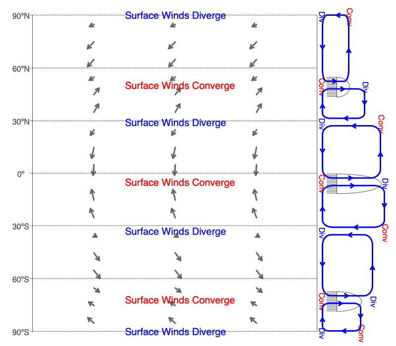
Seasonal changes of the global circulation cells that create divergent and convergent surface winds. The tropical convergence zone shifts the furthest north in July and is at its most southern extent in January.
Combination of All Three
Low-pressure systems with warm (red) and cold (blue) fronts involve a combination of buoyancy, surface convergence, upper-level divergence, and frontal lifting (a form of mechanical lifting).
Fronts separate air masses of different temperatures and moistures. With a warm front, warm, moist air is blown into the colder, drier air. Warm, moist air is less dense than colder, drier air, so the warm air rises over the colder. In a cold front, cold, dry air is blown into warmer, moister air. The cold, dry air pushes the warmer, moister air off the ground. In both cases, the moister-laden air rises, producing clouds and precipitation.
Earth Systems won’t focus much on frontal lifting, but it will be covered when the meteorology course is developed.
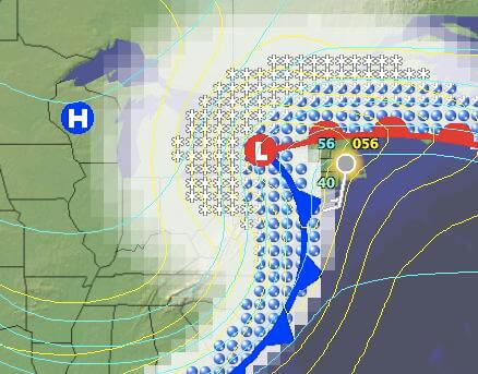
A weather map showing a low-pressure system with a warm front (red, bumpy line) and a cold front (blue, toothed line) extending from the center. Yellow lines are isobars, and blue lines are isotherms. Clouds are shaded in white, rain is highlighted with blue drops and snow in white snowflakes.
Role of the Stratosphere Stopping Rising Air
The warm stratosphere is created as the Sun’s ultraviolet radiation is absorbed by oxygen and ozone. This layer of air will always have a lower density than any air parcel rising from the troposphere, so it keeps convection limited to the troposphere.
There is an interesting research question to explore here. The Earth didn’t have oxygen in its early atmosphere, so the stratosphere couldn’t have existed then. And the stratosphere doesn’t just limit convection; it also creates the three global circulation cells. If circulation cells existed before the stratosphere formed, they most likely were very different from today.
A temperature inversion is when warm air is above cold air. Rising air cools, and the low density of the temperature inversion impedes rising air. In the following images, heated air and smoke from a small forest fire rise until they encounter a temperature inversion. The smoke shows that the air cannot penetrate the inversion.
Think of the stratosphere as the ultimate temperature inversion.
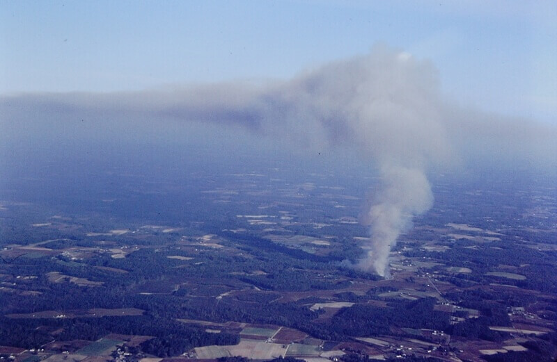
Rising air and smoke from a fire cannot rise into the temperature inversion.
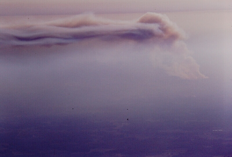
A side view of the rising smoke from a fire interacting with a temperature inversion.
0 Comments