
Drawing Declination Circles
Declination circles map the path of the Sun across the sky as viewed from a point on the Earth’s surface at a given latitude and day of the year. You may use the desktop app, Sun-Earth Connection (download from the Software page), to draw a declination circle, but they are quite easy to draw by hand. Even if you are away from your computer, you may calculate the positions of the Sun and shadows to navigate, estimate the time of day or day of the year, plant your first garden, design awnings for your house, decide if and where to install solar panels on your home, etc. Plus, understanding how the calculations work will help you catch mistakes while using the software.
Drawing Declination Circles web app
Click on the button to run the web app that coaches you through plotting a declination circle by hand. Supporting information on drawing declination circles follows, as well as another button to run the web app.
Click the button to run the Draw Declination Circles web app designed for desktops, laptops, and tablets.
Flattening 3D to 2D
The Sun makes a circular path around us on what we perceive to be a huge sphere surrounding us. It is challenging to draw a sphere accurately, so we are going to “flatten” it to a line make it easier to draw declination and interpret. The horizontal green line represents the horizon (what a person would see standing in a large, flat field). The vertical gray line is the zenith which is the point directly overhead a person. In the displayed template, north is on the left and south on the right. Looking into the paper at the intersection of the horizon and zenith is east, and out of the paper is west.
Seeing Both Sides of the Declination Circle Simultaneously
The last sentence of the previous paragraph may not have jumped out at you, but it is critical to recognize that you see two directions simultaneously using any of these projections. In the North-South projection, where north is to the left, south is to the right, zenith at the top, and the horizon the green line bisecting the circle, each point represents two directions: one into the drawing (labeled in blue) and the other extending from the drawing (labeled in purple). And, to add to the fun, a direction may be described as degrees from one of the cardinal directions, but there are two acute angles to each intercardinal direction.

A North-South declination circle template with the directions labeled. Each point on the diagram represents two directions simultaneously, and directions have multiple notations.
Changing Your Perspective
Declination circles show the Sun’s motion through thy local sky above the horizon, but we can view the setting from different locations. Use the Rotate Horizon web app to explore how directions and sun angles change while viewing the scene from different angles.
Click the button to run the Rotate Horizon web app designed for desktops, laptops, and tablets.
Although you can view the animation made of the Rotate Horizon web app, running the app on your own has several advantages:
-
- The images will be larger.
- You may view any perspective as long as you like, so you may study and/or draw the images that help you most.
- You may save screenshots.
Suggestion: If you have set your computer screen/computer to sleep at a short time interval, you will lose what you are viewing when running the web app. Consider changing your settings to give yourself time to work with the app as you like.

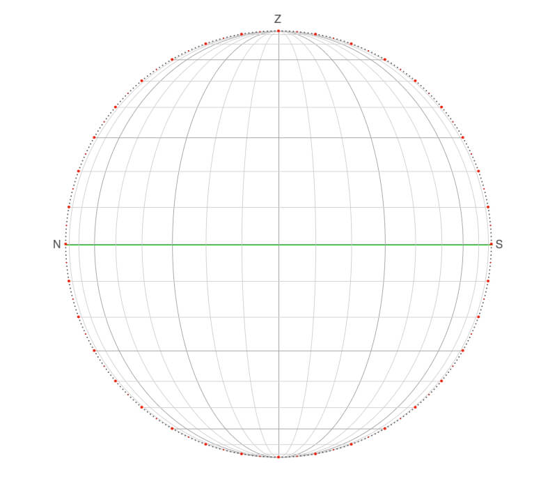
Animation of viewing the horizon and sky grids from changing perspectives using the Rotate Horizon web app. It is important to visualize how the Sun moves three-dimensionally across the sky when viewing declination circles. The horizon is green, and the sky pale blue. The cardinal directions are marked by green lines and labeled N, S, E, and W, and zenith is labeled Z and marked with a red dot.
Drawing Declination Circles by Hand
The Drawing Declination Circle web app coaches you through the four basic steps to drawing a declination circle for any latitude and day of the year. There are written and visual hints, tips, and feedback for each step, and you may set the date and latitude yourself or use the random option to challenge yourself.
Click the button to run the Draw Declination Circles web app designed for desktops, laptops, and tablets.
Acknowledgments
Matti Horne’s insights, suggestions, and a keen eye for detail greatly improved the app during several iterations.

Screenshot from the Drawing Declination Circles web app.
Download Templates to Draw Declination Circles
Below are three useful templates to print so you may work out complex geometric relationships with a ruler, a pencil, and one of these templates without using a computer!
You only need to use a ruler to draw declination circles using the two North-South views to interpret the position of the Sun in the sky. The curved vertical arcs show direction every 10º, and the horizontal lines the altitude of the Sun above the horizon every 10º.
The map view template is useful for navigation applications. The straight lines are directions every 10º, and the circles are the Sun’s altitude every 10º.
To make it easier to plot and interpret, dots mark every degree on the outer circle, every tenth dot is red, and the direction and altitude lines/curves are darkened every 30º.
For the other orientations, see the Sun-Earth Connection software.

A plain North-South viewing template to draw declination circles.
Click on the image to download its template.
A North-South declination circle template with direction grid lines extending from the zenith to the nadir (point directly below the observer) and sun angle grid lines parallel to the horizon. Each set of grid lines is every 10º.
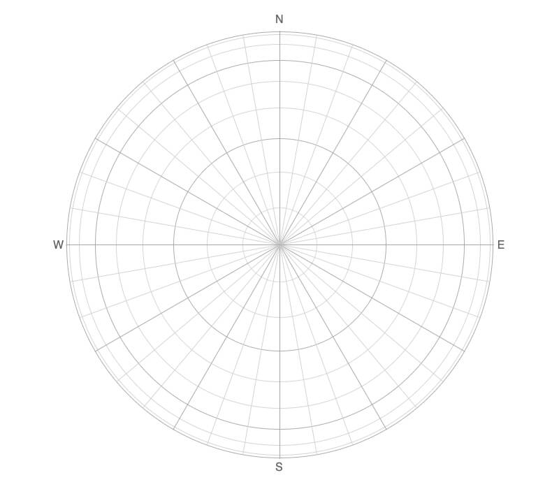
A map-view (or overhead view) template with gridlines every 10º to draw declination circles.
Drawing Three Key Declination Circles
As much as I love computers, to learn how something works, you need to try it in various ways. The declination circle animations, illustrations, and software on this website are helpful, but to develop a much deeper understanding, try to draw and interpret declination circles created manually. It is similar to using a calculator. Will you become proficient in addition, subtraction, multiplication, and division if you always rely on this electronic marvel?
1) Equinox
Draw a declination circle for an equinox since these are the easiest to draw. All declination circles go through the center of the template during an equinox.
In this example, the latitude is 60ºN— all northern latitude declination circle slope toward the north. Think of sliding down the line, and you are heading toward the hemisphere you are in. Go the degrees latitude from the zenith toward the south and place a dot.
The declination circle intersects the ticked-marked outer circle representing two important times of the day: local noon (above the horizon) and local midnight (below the horizon). The Sun is highest in the sky at local noon (Sun is crossing the observer’s longitude) and farthest below the horizon (or lowest in the sky if the Sun doesn’t set that day) at local midnight. Notice that the Sun is only 30º above the horizon at local noon (90º (or zenith) – 60º = 30º) during the equinox when you are at 60ºN.
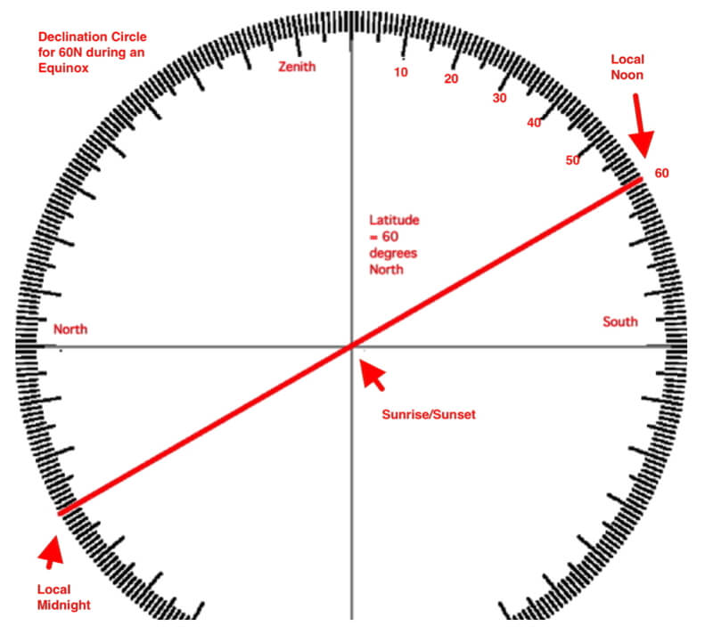
First, draw the declination circle for 60ºN at the equinox. Go 60º from zenith toward the south.
2) Summer Solstice
Draw the declination circle for the summer solstice. Since 60ºN is in the Northern Hemisphere, the summer solstice occurs on June 21, which is the time the Sun is located “over” 23.5ºN, which is known as the Tropic of Cancer. You only need to establish two points to draw the declination circle, so go 23.5º (Earth’s obliquity) toward the north for both local noon and local midnight for the declination circle of the equinoxes (drawn during Step 1).
If drawn correctly, the new declination circle will be parallel to the first one drawn for the equinoxes. Notice that the majority of the declination circle is above the horizon, so the amount of daylight is much longer than 12 hours. The intersection of the June 21 declination circle and the horizon is well north of east. Sunrise is north of east and sunset north of west. The Sun is well south of you at local noon. Using the diagram, the Sun is 53.5º above the horizon at local noon (30º + 23.5º = 53.5º).
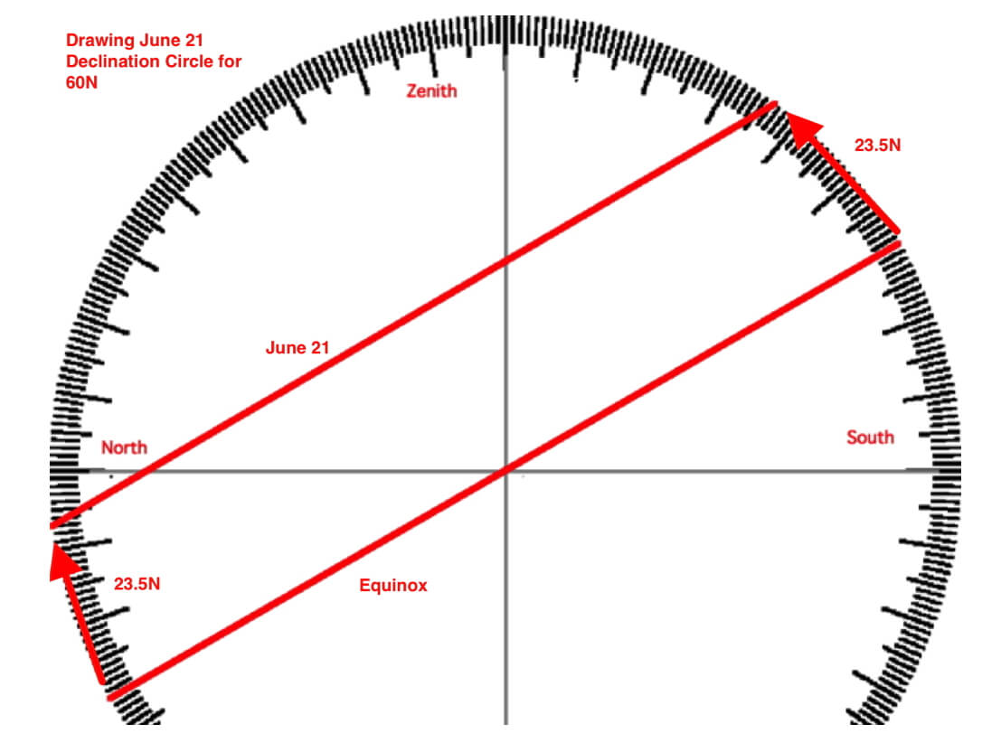
Second, draw the declination circle for 60ºN during June 21, the Northern Hemisphere’s summer solstice.
3) Winter Solstice
Draw the declination circle for the winter solstice. Since the location is in the Northern Hemisphere, the winter solstice will occur on December 21, which is the time the Sun is located “over” the 23.5ºS or the Tropic of Capricorn. Go 23.5º toward the south for both local noon and local midnight for the declination circle of the equinoxes (drawn in Step 1).
Now the majority of the declination circle is below the horizon, so the amount of daylight is much shorter than 12 hours, and it is equal to the amount of darkness during the summer solstice. The Sun rose well south of east and set well south of west (remember, look at the intersection of the declination circle and the horizon). The Sun was still south of you at local noon – but it is 6.5º above the horizon (30º-23.5º).
Notice the symmetry between the winter and summer solstice declination circles. The location of sunrise and sunset for the two solstices are symmetric about east and west, respectively. The sun rose at 53º north of east on June 21, then it rose 53º south of east on December 21. Similarly, the sunset was 53º north of west on June 21 and 53º south of west on December 21. and The time of sunrise and sunset for the two solstices are symmetric about 6 AM and 6 PM, respectively:
6 AM – SunriseSummer Solistice = SunriseWinter Solstice – 6 AM
SunsetSummer Solistice – 6 PM = 6 PM – SunsetWinter Solstice
Also, the amount of daylight and nighttime for the solstices are symmetric about 12 hours, meaning the amount of daylight during June 21 equals the amount of darkness during December 21, and vice versa during June 21.

Third, draw the declination circle for 60ºN during December 21, the Northern Hemisphere’s winter solstice.
Declination Circles for Other Days of the Year
So we can draw declination circles for four days of the year, but what about the other 361 days? You may use the circles already drawn to help bracket declination circles for different times of the year. In drawing of the declinations circles for the 21st of each month for 42ºN, notice that the spacing between months is not even. There is a greater change during the months around the equinox compared to around the solstices.
To calculate the number of degrees away from the equinox declination circle, use the solar declination graph and web app. The declination for the summer solstice in the northern hemisphere is 23.5ºN or +23.5º; for the southern hemisphere, it is 23.5ºS or -23.5º. As you did when drawing the solstice, go the degrees declination from the local noon and local midnight points of the declination circle.
Once you have drawn the declination circle for the chosen day of the year, use the information to plan your day, outing, how and when to photograph or shoot your movie, or where to plant your garden or what plants you should consider growing.
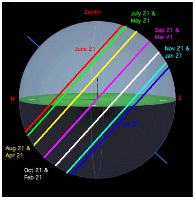
Declination circles for the 21st of each month for 42ºN.
Big Ideas
- Declination circles map the path of the Sun across the sky as viewed from a point on the Earth’s surface at a given latitude and day of the year.
- To draw a declination circle by hand, you need to know your latitude and the solar declination for the day you are interested in.
Click on the following toggles to view descriptions and links of the web pages on each topic of the Sun-Earth Connection.
Sun-Earth Connection overview
An overview of how the Sun’s energy is generated and how its thermal radiation illuminates and heats Earth.
Earth Illumination Patterns
- Overview: The Sun illuminates the spherical, rotating planets orbiting it.
- Obliquity and Earth’s Illumination: Obliquity is the angle between the planes of the Earth’s equator and its orbit around the Sun.
- Declination, Latitude, & Earth Illumination: Solar declination is the angle between the Sun’s rays and the plane of the Earth’s Equator. Its value depends on where Earth is in its orbit around the Sun.
- Astronomical Seasons & Illumination: Astronomical seasons are based on the orientation of Earth’s axis of rotation to the Sun, which determines the amount of illumination between the Northern and Southern Hemispheres.
Distribution of the Sun's Energy on Earth
- Overview: Even though an area is illuminated by sunlight, there can be quite a range of energy interacting with the surface.
- Sun Angle and Beam Concentration: If every beam of sunlight reaching Earth has the same amount of energy, why do some areas warm up more than others?
- Diurnal Heating: Diurnal heating is the temperature change over 24 hours. When sunlight shines on the ground, it warms. Two critical factors that determine the amount of heating deal with the Sun’s illumination.
- Seasons: Earth experiences astronomical seasons due to its obliquity.
- Climate Regimes: Climate regimes are an extension of diurnal heating and seasons, but the time frame is now years.
Declination Circles: A tool to analyze the Sun's position in the sky.
- Overview: Drawings of declination circles contain the visual and numerical information to understand and predict the Sun’s motion across the sky.
- Declination Circles 101: Draw a declination circle with just a ruler and protractor/compass to quickly and accurately know the Sun’s position in the sky at any day and time of the year for any location on Earth.
- Drawing Declination Circles: Declination circles are quite easy to draw by hand.
- Interpreting Time on Declination Circles: Accurately estimate the time of day using the Sun’s location in the sky.
- Sunrise, Sunset, & Twilight: Calculate the timing and duration when the Sun is at or near the horizon.
- Solar Time, Angle, & Position: The sun’s angle and direction to the local horizon define the Sun’s position in the local sky. Explore how to use declination circles to calculate the Sun’s position at any solar time anywhere in the world on any day of the year.
- Changing Views of Declination Circles: Use the web app View Declination Circles to explore three common views of declination circles to identify their strengths, limitations, and applications. Then learn how to go from one view to another.
- Using Declination Circles: Humans have been using the apparent motion of the Sun as a compass, clock, and calendar for millennia.
- Using Sundials: Humans have been using the Sun’s position to navigate and tell the time, day, and season for millennia. Sundials create shadows that make it easier to do these tasks.
I am often to blogging and really appreciate your content 🙂
Thank you, Kiana! If you have suggestions for topics not covered yet, please let us know.
Kindly,
The Team at Science Pickle