
Using Declination Circles
Humans have been using the apparent motion of the Sun as a compass, clock, and calendar for millennia. And we can use it for so much more today: photography, art, green technologies, agriculture, and energy-efficient buildings, to name a few. The following challenges involve several of the ways we use our understanding of the Sun’s motion.
If you are familiar with the app, click the button to run the web app to test how your awning design works throughout the year. There is supporting information for the app and a second button to run it below.
Location Challenges
Sunset Challenge
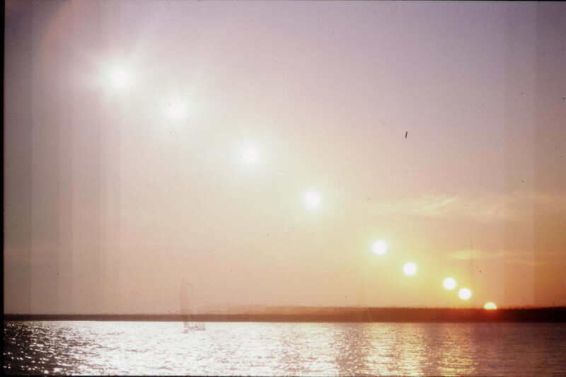
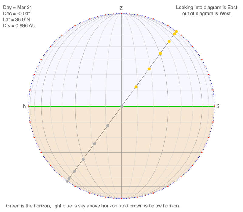
This is a timelapse photograph of a sunset. What hemisphere was it taken in? Northern or southern?
Answer
Since it is sunset, we are looking in a westward direction, so north is to the right. The Sun is setting with a northward component (imagine sliding down the line connecting the Sun images, you would be sliding toward the north as the Sun set). Declination circles slope northward in the Northern Hemisphere.
This photograph was taken in central North Carolina (latitude ~ 36ºN) in the early 1980s with a film camera. If the film had not moved slightly with each rewind of the camera, we could have estimated the location’s latitude, which is equal to the angle of the Sun’s motion from vertical.
Sunrise Challenge
This is a timelapse movie of a sunrise. In which hemisphere was it filmed? Northern or southern?
Answer
Since it is sunrise, we are looking in an eastward direction and north is to the left. The plane of the sun’s motion is sloping northward, so it’s in the Northern Hemisphere.
This movie was taken on Cape Cod at a latitude of 42ºN, so the Sun’s motion at sunrise is 42º from vertical or 48º from the horizon (90º – 42º).
Another Sunset Challenge
This is a timelapse movie of a sunset. At what latitude was it filmed? Include the hemisphere!
Answer
Thomas Ysrael from Tamuning, Guam (latitude = 13.5 ºN), made the timelapse movie of this beautiful sunset.
Notice that as the sun sets, it is moving slightly to the right each frame. Since sunset occurs toward the west (rarely is it exactly west), north is to the right in the movie. An easy way to know what hemisphere while watching a sunset is that the sun moves somewhat northward if in the northern hemisphere, and southward when in the southern hemisphere. And if standing on the Equator? The sun sets perpendicular to the horizon. And if at the North or South Pole? The sun stays at the same altitude above the horizon as it makes a complete circle in the sky.
In the movie, if you measured the angle the sun sets relative to the horizon, it would be 90º – 13.5º or 76.5º
Note that the sun is not moving; we are watching the effects of Earth rotating.
Want to make your own timelapse? There are several free apps for your smartphone. The key is to keep your camera vertical and stationary as you film. If possible, a tripod is handy in keeping your phone stable and perpendicular. Start at least a half an hour before sunset. If filming a sunrise, allow for a half an hour of filming after the sun is above the horizon.
Finally, when you go to a remote tropical beach to watch a romantic sunset, take a flashlight with you! The sun will set very quickly below the horizon, and you have an unexpectedly short twilight compared to what you are used to if you live poleward of 30º latitude. The romance soon disappears as you stumble along in the dark.
Sundial Challenge
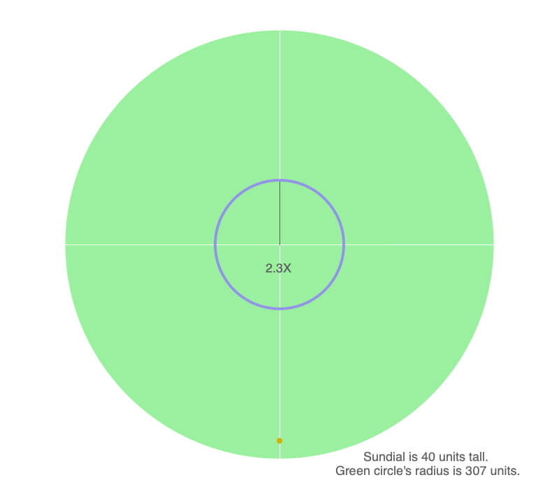
The purple dots are the locations of a tip of a sundial’s shadow when the Sun is above the horizon. You are directly over the sundial looking down on it.
The radius of the shadow trace is 2.3 times larger than the height of the sundial, which is a vertical stick.
Try making your own sundial and recording the shadows during daylight hours. See Making and Using a Sundial.
At what latitude was this made?
There are only two places in the world where shadows would trace a circle around a sundial: the North and South Poles. The sun moves in a declination circle parallel to the horizon.
What day of the year was this made? Hint: Use trigonometry.
You need to calculate the angle of the Sun above the horizon, and since the sundial is a vertical stick, use right angle trigonometry.
The side adjacent to the sun angle is 2.3 times longer than the height of the sundial.
Tan (sun angle) = opposite side / adjacent side
= sundial height / shadow length
= 1 / 2.3
Rewriting this, sun angle = tan¯¹(1 / 2.3) = 23.5º
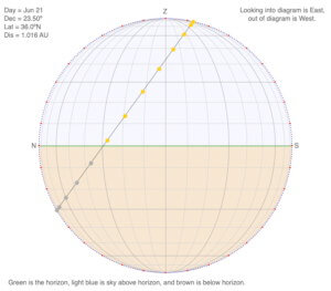
The only time the Sun is 23.5º above the horizon is during the summer solstice.
So if this were the South Pole, it is December 21, and if the North Pole then June 21 (see below).
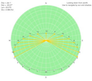
Navigation Challenge
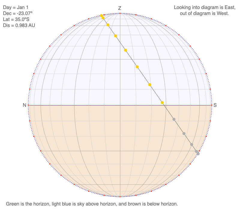
You are going hiking starting at 8 AM on January 1 at 35ºS. You are in the exact middle of your time zone, so clock time and sun time are equal.
You are leaving on a path heading north. There are many paths through the area, so you need to know where the Sun will be when you get back to the final trail (so you will be walking south) 10 hours later. Where is the Sun located with respect to you (on your left shoulder, behind you, etc.?) as you leave for your trip and when you return?
Use the North-South oriented declination circle.
Answer
You needed to convert the information from the N-S declination circle to a view of the declination circle from above.
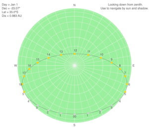
The sun is shining nearly directly on your right side as you depart, and it should be roughly 30º in front of your right shoulder on your return at 6 PM (18 in the diagram).
The sunbeams for the hourly positions are drawn to make it easier to visualize how the sun is hitting you as you walk.
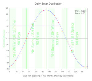
Date Challenge
You are traveling for vacation. While you were flying to your favorite place to relax, the plane loses its navigation system but lands safely in an unknown location. Since you are a declination circle expert, you make measurements that create this declination circle.
What is your latitude?
You are reversing the steps in Drawing Declination Circles.
To create a parallel declination that passes through the center of the diagram (so the declination circle for the equinox), so 11º south from local noon and local midnight. From this new line, the latitude is 90º – local noon sun angle = 90º – 66º = 24ºS.
What are the two possible days this could occur?
Going from the equinox declination circle to the one you measured, you went 11ºN. There are two possible dates with this declination: April 18 and August 24.
If tomorrow's shadows are longer than today's, what day is it?
If the shadow is longer, the Sun is lower in the sky the next day – and a smaller declination. Looking at the annual declination graph, this means the day you measured the declination circle was August 24.
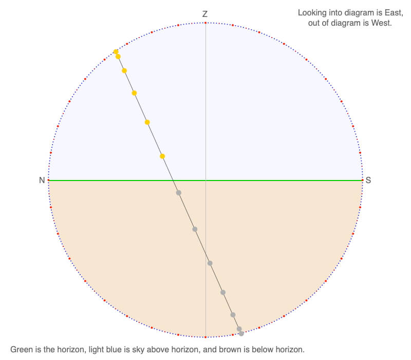
Photography Challenge
K2 is a famous Himalayan mountain located at 36ºN. You are to photograph the north-facing side of the mountain when it is bathed in sunlight. What days of the year and times of day will allow you to do this?
Use the declination circle for K2 on the equinox as guidance. The curved vertical arcs show the direction of the Sun in the sky. The arcs are separated by 10º.
Answer
Create a declination circle for K2 at the summer solstice, June 21, and see which times of the day are north of K2. If you like, create an overhead view of the declination circle to visualize when K2 will be illuminated.
A few hours before sunrise and sunset between mid-April and the end of August (there are more dates where the Sun is slightly north of east at sunrise and north of west at sunset and there is much less time available to shoot).
Design and Test Awnings
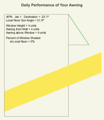
Awnings are an energy-efficient and relatively inexpensive technology that blocks sunlight from entering a building during the warm months but lets the sunshine into the building during the cold months. But what design works best for your latitude?
Use the Awning Design web app to design an awning and test how well it blocks noontime sunlight from entering a window in the summer yet lets winter light in for your latitude.
There are three variables to work with:
-
- The height of the window,
- The distance the awning extends horizontally from the wall (called “Awning from Wall” in the diagram), and
- The height of the end of the canopy above the top of the window (labeled “Awning Above Window”).
Lengths do not have units in the software, which means that as long as you use the same length units throughout, the calculations will work. So if you work in meters, all measurements should be in meters.
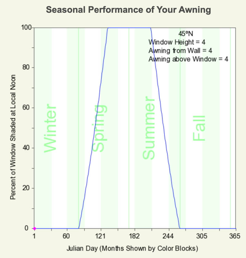
In the animation, a beam of sunlight is shown for twelve times of the year. View how much light enters the building at the selected latitude of 45ºN. Change the awning and window dimensions to create the best design of energy-efficient windows throughout the year.
Click the button to run the web app to test how well your awning design works throughout the year.
Above is an animation of an awning shielding a window from noontime sunlight during the summer months yet lets light into the room during the winter months. Below is the graph of the seasonal performance of the awning.
Real-Life Awning Test
Nicky Longo and Isabelle Stromberg created an experiment to see how well awnings would work to cool a classroom at Concord Academy, Concord, MA. They found that the room shaded by the awning was significantly cooler than those without awnings. Surfaces in the shaded room were up to 30ºF cooler than for the surfaces in the unshaded room.
Notice that the sun’s angle above the horizon doesn’t change much during the hour just before to just after local noon allowing the awning to block out most of the sunlight during this time of day. Use the declinations that follow to study how the sun changes altitude above the horizon and direction at different times of the day.
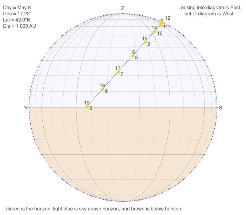
The North/South-oriented declination circle for 42ºN on May 8 shows how the sun’s position change altitude in the sky (the horizontal lines are 10º apart) and direction (the curved vertical arcs are 10º apart) through daylight hours. The hourly position of the Sun is shown as a yellow circle.
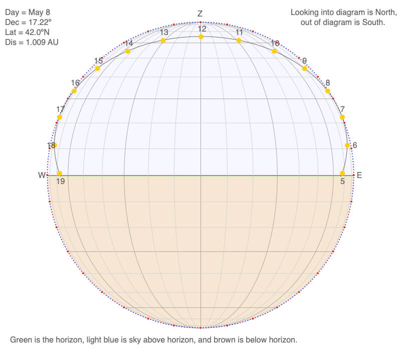
The East/West-oriented declination circle for 42ºN on May 8 shows how the sun’s position change altitude in the sky (the horizontal lines are 10º apart) and direction (the curved vertical arcs are 10º apart) through daylight hours. The hourly position of the Sun is shown as a yellow circle.
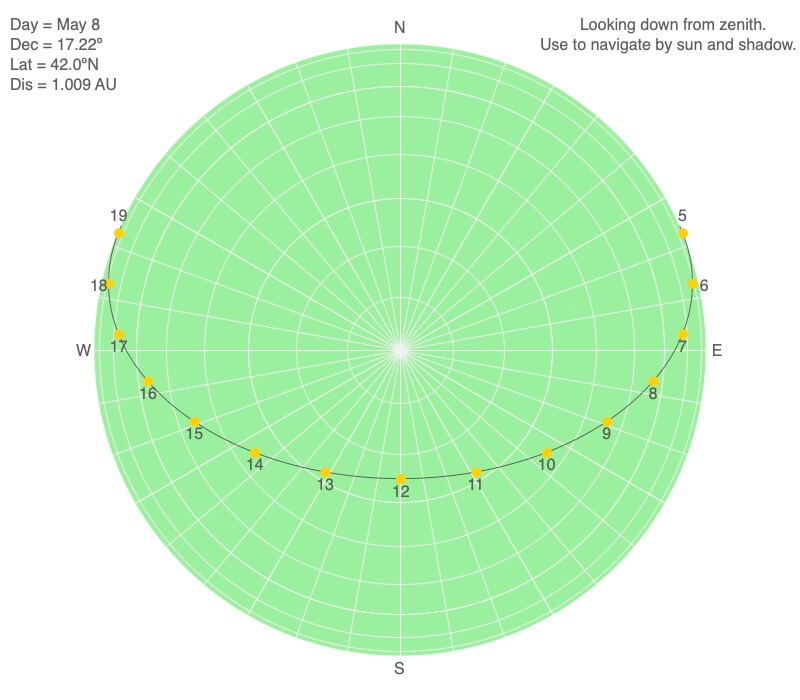
The map view declination circle for 42ºN on May 8 shows how the sun’s position change altitude in the sky (the circles are 10º apart where the center point is 90º above the horizon) and direction (the straight lines are 10º apart) through daylight hours. The yellow circles represent the hourly position of the Sun.
Big Ideas
- Humans have been using the apparent motion of the Sun as a compass, clock, and calendar for millennia. And we can use it for so much more today.
Click on the following toggles to view descriptions and links of the web pages on each topic of the Sun-Earth Connection.
Sun-Earth Connection overview
An overview of how the Sun’s energy is generated and how its thermal radiation illuminates and heats Earth.
Earth Illumination Patterns
- Overview: The Sun illuminates the spherical, rotating planets orbiting it.
- Obliquity and Earth’s Illumination: Obliquity is the angle between the planes of the Earth’s equator and its orbit around the Sun.
- Declination, Latitude, & Earth Illumination: Solar declination is the angle between the Sun’s rays and the plane of the Earth’s Equator. Its value depends on where Earth is in its orbit around the Sun.
- Astronomical Seasons & Illumination: Astronomical seasons are based on the orientation of Earth’s axis of rotation to the Sun, which determines the amount of illumination between the Northern and Southern Hemispheres.
Distribution of the Sun's Energy on Earth
- Overview: Even though an area is illuminated by sunlight, there can be quite a range of energy interacting with the surface.
- Sun Angle and Beam Concentration: If every beam of sunlight reaching Earth has the same amount of energy, why do some areas warm up more than others?
- Diurnal Heating: Diurnal heating is the temperature change over 24 hours. When sunlight shines on the ground, it warms. Two critical factors that determine the amount of heating deal with the Sun’s illumination.
- Seasons: Earth experiences astronomical seasons due to its obliquity.
- Climate Regimes: Climate regimes are an extension of diurnal heating and seasons, but the time frame is now years.
Declination Circles: A tool to analyze the Sun's position in the sky.
- Overview: Drawings of declination circles contain the visual and numerical information to understand and predict the Sun’s motion across the sky.
- Declination Circles 101: Draw a declination circle with just a ruler and protractor/compass to quickly and accurately know the Sun’s position in the sky at any day and time of the year for any location on Earth.
- Drawing Declination Circles: Declination circles are quite easy to draw by hand.
- Interpreting Time on Declination Circles: Accurately estimate the time of day using the Sun’s location in the sky.
- Sunrise, Sunset, & Twilight: Calculate the timing and duration when the Sun is at or near the horizon.
- Solar Time, Angle, & Position: The sun’s angle and direction to the local horizon define the Sun’s position in the local sky. Explore how to use declination circles to calculate the Sun’s position at any solar time anywhere in the world on any day of the year.
- Changing Views of Declination Circles: Use the web app View Declination Circles to explore three common views of declination circles to identify their strengths, limitations, and applications. Then learn how to go from one view to another.
- Using Declination Circles: Humans have been using the apparent motion of the Sun as a compass, clock, and calendar for millennia.
- Using Sundials: Humans have been using the Sun’s position to navigate and tell the time, day, and season for millennia. Sundials create shadows that make it easier to do these tasks.
0 Comments