
Earth’s Coordinate System
Latitude and Longitude
Earth is a rotating sphere, so its coordinate system uses latitude and longitude to locate positions on the planet. Earth’s axis of rotation orients latitude so that the axis is the center of every latitude circle. Since a latitude circle is perpendicular to the axis of rotation, every point along a given latitude experiences the same illumination patterns of the Sun on any given day of the year: location of sunrise and sunset, amount of daylight and darkness, angle of the Sun above the horizon at local noon, etc. The National Geographic website shows the range of definitions for the horizon. We will use the astronomical horizon: the perpendicular horizontal plane to the observer’s zenith (the point directly above the observer).
Latitude
Latitude circles, which are points around the globe with the same latitude, are perpendicular to Earth’s axis of rotation. The North and South Poles are where the axis of rotation intersects the Earth’s surface. The North Pole is 90ºN, and the South Pole is 90ºS. Because the Earth is rotating, every person at a given latitude experiences the same pattern of the Sun’s apparent motion throughout the day.
Conventions of Latitude
- The North Pole is 90ºN, the South Pole is 90ºS, and the Equator, halfway between the Poles, is 0º.
- Latitudes have positive and negative values. Northern Hemisphere latitudes are positive, and negative latitudes occur in the Southern Hemisphere.
- The largest latitude circle (greatest radius and perimeter) occurs at the Equator (0º), the smallest at the Poles.
- The distance between one degree of latitude is a constant 60 nautical miles or 111 km.
- If you look in the direction of constant latitude, you are facing either east or west.
There are many ways to think about latitude, and each has value in how we navigate and how the Sun warms the Earth. Examine the three images that follow for examples.

Labeled latitudes every 15º extending from the North Pole to the South Pole. Notice that the latitude circles are evenly spaced apart. The latitude with the largest radius is the Equator (0º). At the Poles, the circle is a point, so the radius is 0 km.
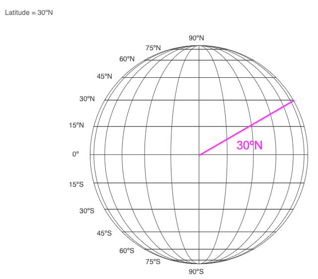
1) Imagine standing at the center of the Earth and oriented parallel to the Earth’s axis. Looking straight ahead, you would be viewing the Equator (0º). You would see the North Pole (90ºN) directly overhead, and the South Pole (90ºS) would be straight down. If you looked 30º above the Equator (magenta line), you would be looking at 30ºN.
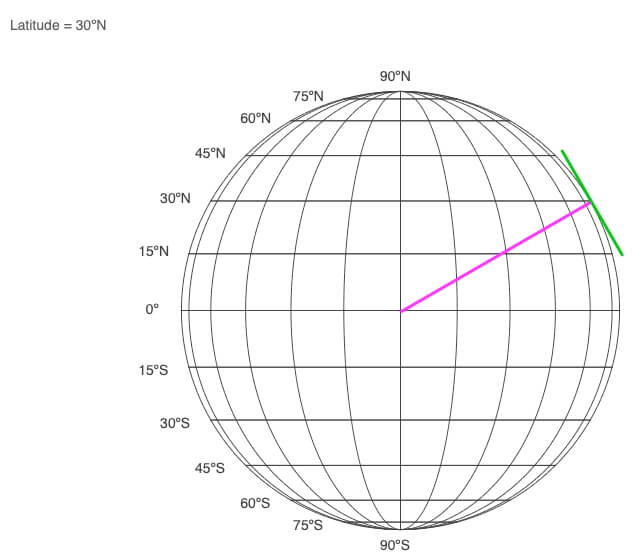
2) The horizon is the flat piece of real estate surrounding you when standing at a particular location. The green line in this example is the horizon for a person standing at 30ºN. Latitude determines the orientation of the horizon relative to the axis of rotation.
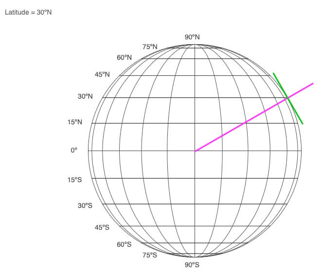
3) The point directly overhead a person is the zenith. Notice that it is an extension of the line of latitude (magenta) extending from the center of the Earth to the point directly overhead someone (zenith) standing at 30ºN.
The zenith line and the horizon are always perpendicular to each other.
Notice how the orientations of the horizon and zenith change as latitude changes from 90ºN to 90ºS. At the poles, the horizon is perpendicular to the axis of rotation, and at the Equator (0º), the horizon is parallel to it.
These spatial connections will be essential to apply in the Sun-Earth Connection and Star-Planet Connection sections.
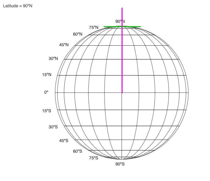
The orientation of the horizon (green) and zenith (magenta) depend on one’s latitude.
Longitude
Longitude is parallel to the axis of rotation, but political, geographic, economic, aesthetic and/or logical reasons dictate the location of 0º. For Earth, 0º goes through the British Royal Observatory in Greenwich, England. A line of longitude, or a meridian, creates a half-circle between the North and South Poles.
Conventions of Longitude
- The Prime Meridian is 0º, and the International Date Line is 180º.
- Longitudes have positive and negative values. Positive longitudes are in the Eastern Hemisphere (east of the Prime Meridian), and negative ones occur in the Western Hemisphere (west of 0º).
- All lines of longitude meet at the Poles, so the distance between one degree of longitude is not constant. It is 0 km at the Poles and 60 nm (111 km) at the Equator.
- If you look in the direction of constant longitude, you are facing either north or south.
The Earth rotates counterclockwise in the Northern Hemisphere but clockwise in the Southern Hemisphere. To be more consistent, the Earth rotates from west to east since this works in both hemispheres. This is easy to remember since the east coasts of continents experience sunrise before the west coasts.
Longitude defines our time zones, where, discounting geopolitical boundaries, each hour is 15º longitude wide (360º / 24 hours = 15º). The time zone that includes the Prime Meridian extends between 7.5ºW and 7.5ºE.
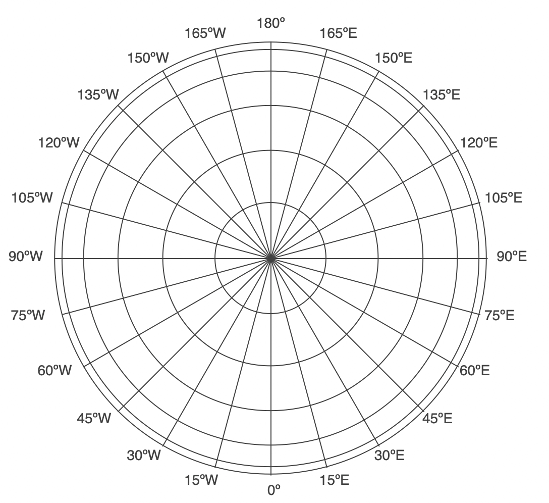
Above are longitudes every 15º extending around the globe. The Prime Meridian is 0º, and the International Dateline is 180º.
Big Ideas
- Earth’s spherical shape and its axis of rotation define our coordinate system.
- Latitude circles are perpendicular to the axis of rotation.
- Longitude meridians are parallel to the axis of rotation.
0 Comments