Changing Views of Declination Circles
Where you view a three-dimensional object defines what you can observe. For example, a two-dimensional declination circle cannot capture the three-dimensional motion of the sun across the local sky without some distortion or loss of data. Use the web app View Declination Circles to explore three common views of declination circles to identify their strengths, limitations, and applications. Then learn how to go from one view to another.
Acknowledgments: Matti Horne’s many contributions during our brainstorming and review sessions expanded this app in new directions.
Click the button to run the View Declination Circle web app designed for desktop, laptop, and tablet computers.
The animations and illustrations on this page are screenshots from the web app.
Benefits of Running the Web App
Although you can view the following animations made using the View Declination Circle web app, running the app on your own has several advantages:
-
- The images will be larger.
- You may view any perspective as long as you like, so you may study and/or draw the images that help you most.
- There are additional visualizations and activities to explore.
- Test your understanding by predicting the outcome of new settings before making the change in the app.
- You may save screenshots of visualizations you created.
Suggestion: If you have set your computer screen/computer to sleep at a short time interval, you will lose what you are viewing when running the web app. Consider changing your settings to give yourself time to work with the app as you like.
Compare Sun Position
N/S-oriented declination circles (dark gray) are created by looking eastward from a distant point in the horizon plane (green). From this perspective, the declination circle appears to be a straight line in which its tilt from the horizon is 90º minus the degrees of latitude. This is the easiest declination circle to draw, requiring only a straight edge and a protractor.
E/W-oriented declination circles are created by looking northward from a distant point in the horizon plane. From this perspective, the declination circle appears as an ellipse with the longest axis parallel to the horizon and the short axis in the vertical.
In the adjacent animations, compare the sun’s hourly movement when viewed with each declination circle. Does one view completely illustrate how the Sun appears to move throughout the day?
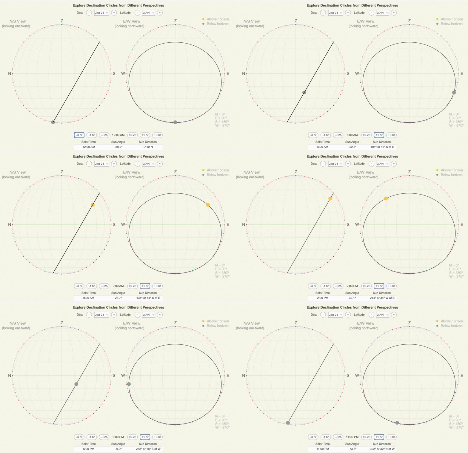
Animations of the hourly movement of the Sun when viewed on North/South and East/West-oriented declination circles. The Sun is orange when above the horizon and gray when below it.
Map-view declination circles are created by looking down from directly overhead the location, so from the zenith. From this perspective, the declination circle appears as an ellipse with the longest axis parallel to the east/west direction and the shortest axis oriented north/south.
In addition to comparing how the Sun appears to move in all three views, notice how the sun angle and direction grids are drawn. Since both sun angle and direction are relative to the horizon, they are drawn differently depending on how the viewer is oriented to the horizon.
As you explore the three views, create a list of the strengths, limitations, and applications.
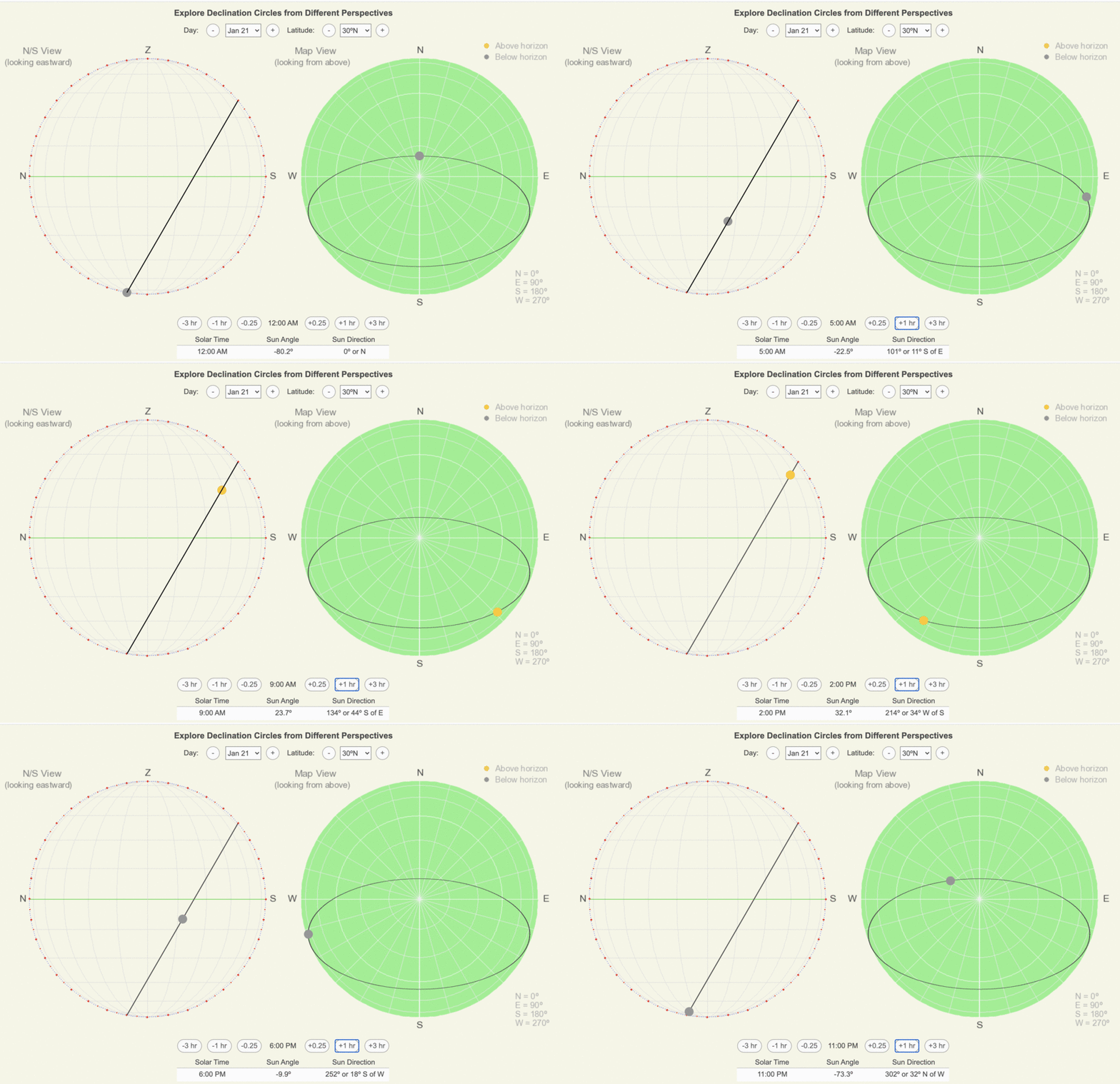
Animations of the hourly movement of the Sun when viewed on North/South-oriented and map view declination circles. The Sun is orange when above the horizon and gray when below it.
Strengths, Limitations, and Applications
N/S View
Strengths
-
- It is easy to see the symmetry of the Sun’s motion (sunrise and sunset occur symmetrically about local noon and are located symmetrically from the North/South line).
- You may quickly see the sun angle of local noon and midnight.
- Once practiced, it is easy to estimate the times of sunrise and sunset and the duration of sunlight and darkness.
Limitations
-
- It is easy to become confused when identifying the sun’s direction.
Applications:
-
- Since this declination circle is easy to draw and interpret, use it to create or conceptualize the other views.
E/W View
Strengths
-
- It is easy to see the symmetry of the Sun’s motion (sunrise and sunset occur symmetrically about local noon and are located symmetrically from the North/South line).
- You may quickly see the sun angle of local noon and midnight.
- It is easy to see the changing sun direction around noontime.
Limitations
-
- It is challenging to estimate time on the ellipse.
Applications
-
- This declination circle is useful for planning windows, solar panels, awnings, buildings, and roofs to capture or reflect the noontime sunshine.
Map View
Strengths
-
- This declination circle provides the easiest visualization of the sun’s direction.
- It is easy to see the symmetry of the sun’s motion about the north/south line.
Limitations
-
- It is challenging to visualize the time and location of sunrise and sunset.
Applications
-
- This declination circle is useful for navigating by the sun’s position in the sky.
Compare Changing the Date
The day of the year represents the Earth’s position is in its orbit around the Sun and how the axis of rotation is oriented to the Sun, which determines the solar declination. The North/South view quickly shows that all declination circles for a given location are parallel throughout the year. Therefore, you can quickly estimate the solar declination from the amount of shift from the equinox circle.
In the following animations, declination circles are drawn for 30ºN on the 21st of each month.
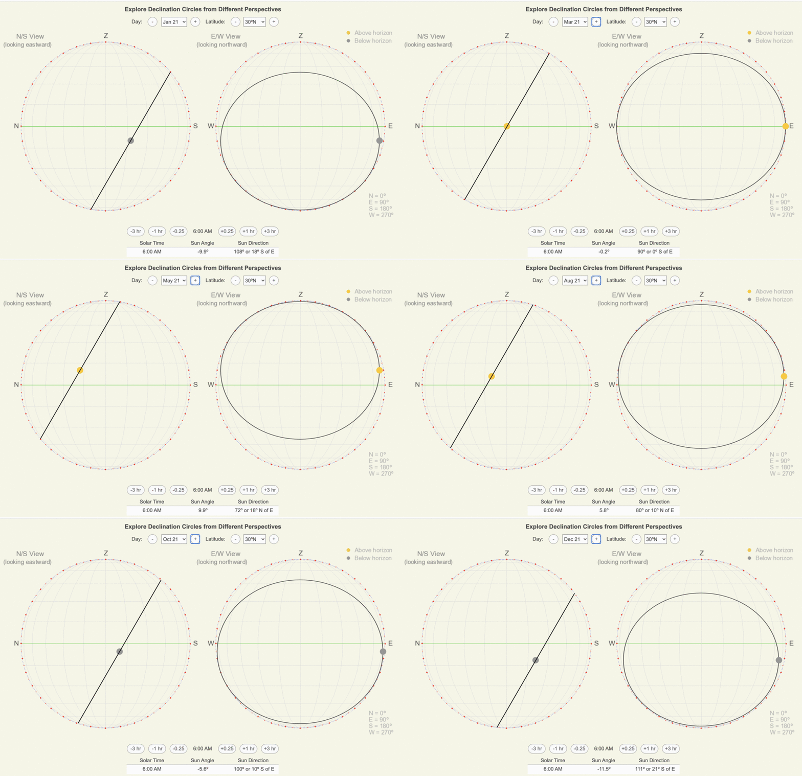
Animations of declination circles for 30ºN on the 21st of each month when viewed on North/South and East/West-oriented declination circles. The sun position is based on 6 AM for each circle.
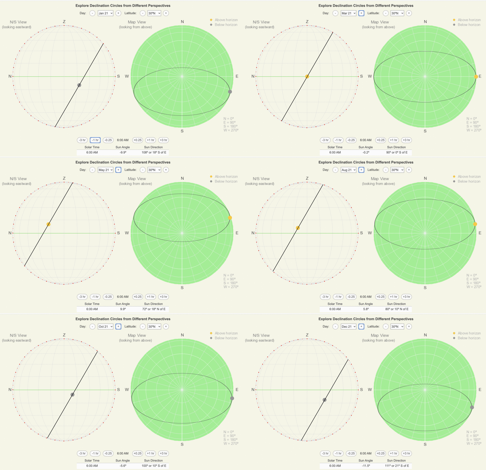
Animations of declination circles for 30ºN on the 21st of each month when viewed on North/South-oriented and map view declination circles. The sun position is based on 6 AM for each circle.
Compare Changing the Latitude
The latitude sets the orientation of the horizon to the axis of rotation and the slope of the declination circle throughout the year. Thus, as the latitude changes, the orientation of the circle changes, and it is much easier to see the new position with the North/South view than the other views.
In the following animations, declination circles are drawn for January 21 as latitude changes.
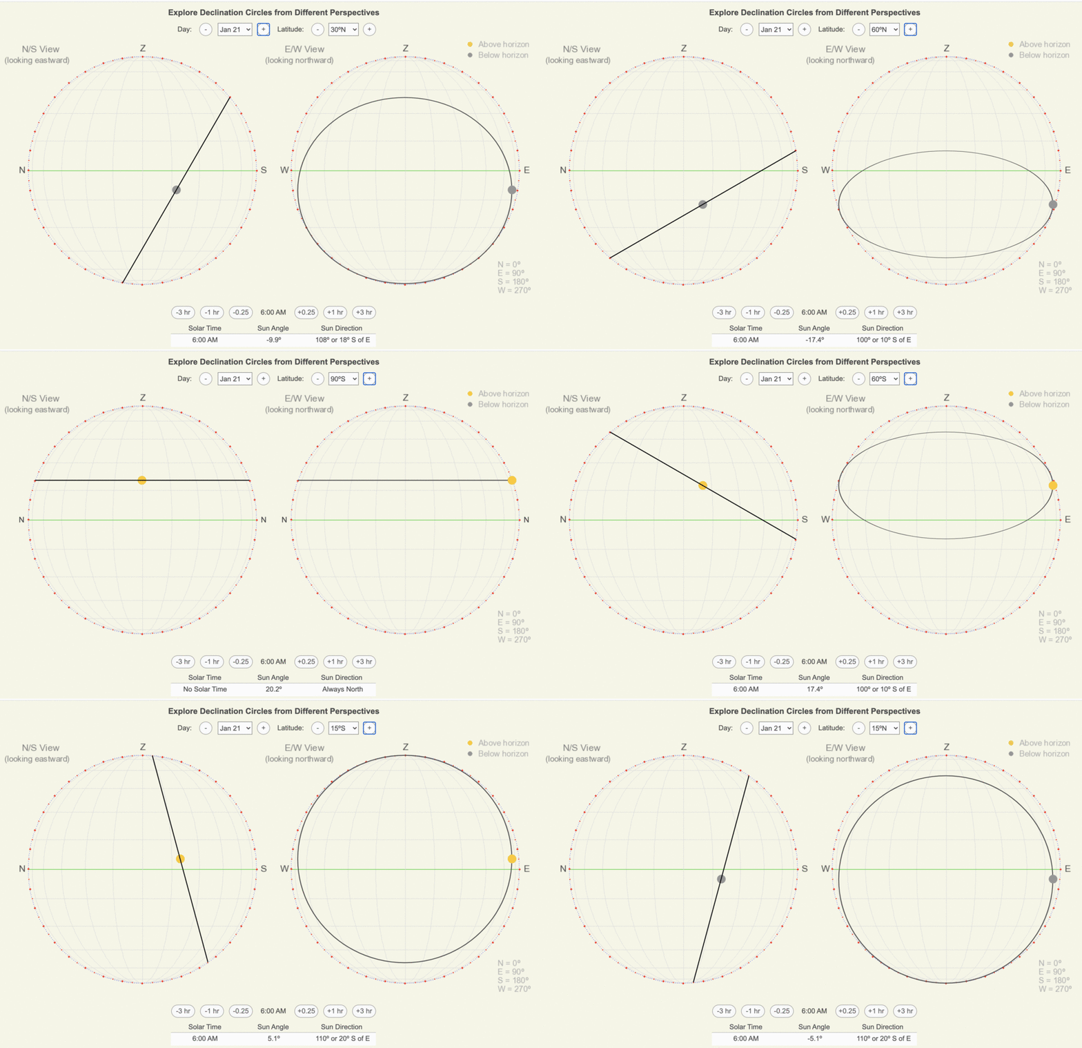
Animations of declination circles for January 21 as latitude changes when viewed on North/South and East/West-oriented declination circles. The sun position is based on 6 AM for each circle.
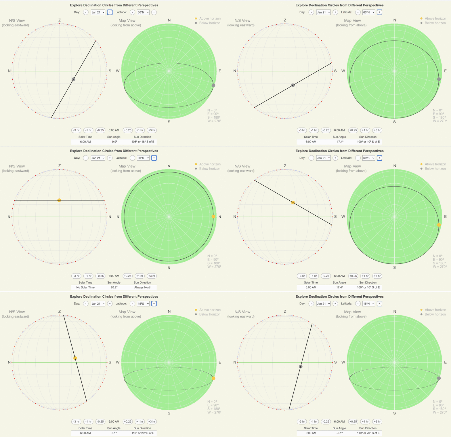
Animations of declination circles for January 21 as latitude changes when viewed on North/South-oriented and map view declination circles. The sun position is based on 6 AM for each circle.
Four Key Sun Positions
Regardless of how we view a declination circle, four sun positions define its orientation and shape:
1) Local Noon (blue dot)
2) Local Midnight (magenta dot)
3 & 4) 6 AM and 6 PM (red dots)
Local noon occurs when the Sun is highest in the sky. Therefore, the local noon Sun is the uppermost point when viewing the declination circle from the horizon (N/S and E/W views).
Local Noon Sun Angle (LNSA) = 90° – Latitude + Solar Declination
When LNSA > 90°, then LNSA = 180° – LNSA
Remember, Southern Hemisphere latitudes are negative: 30°S = -30°
Local midnight is the opposite of local noon, so it is the lowest point on a declination circle viewed from the horizon. Usually, the midnight sun is below the horizon (negative sun angle) except for polar latitudes near the summer solstice.
Local Midnight Sun Angle (LMSA) = 90° – Latitude – Solar Declination
When LMSA < -90°, then LMSA = -180° – LMSA
Halfway between 12 AM and 12 PM are 6 AM and 6 PM, and they both have the same sun angle, which is equal to the average of the noon and midnight sun angles.
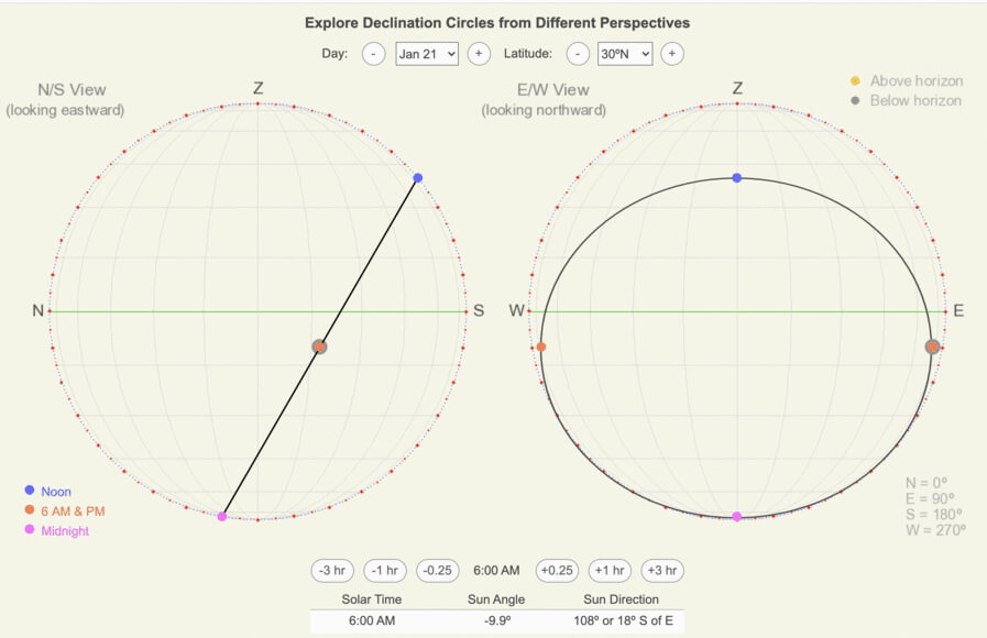
North/South and East/West-oriented declination circles with the positions of the four key points shown: local noon, local midnight, and 6 AM and PM for 30ºN on January 21.
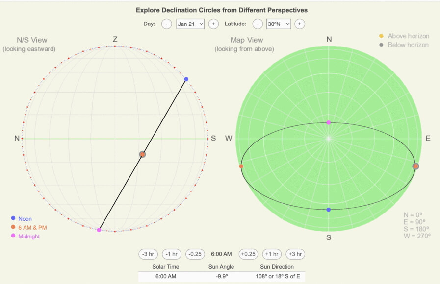
North/South-oriented and map view declination circles with the positions of the four key points shown: local noon, local midnight, and 6 AM and PM for 30ºN on January 21.
Go from N/S to E/W View
Since both views are from the horizon plane, the sun angle grids are identical. Thus, the sun angles for the four key points line up vertically (see the horizontal blue, red, and magenta lines in the adjacent diagram for 30ºN on January 21). Local noon and midnight intersect the north/south line in both diagrams. To position the 6 AM and PM positions, use the sun direction grid. Notice that the 6 AM position is approximately 20º south of east, and the 6 PM position is 20º south of west.
Once these four points are positioned on the E/W-oriented circle, you could sketch in the ellipse or find additional points to transfer from the N/S view, such as sunrise and sunset.
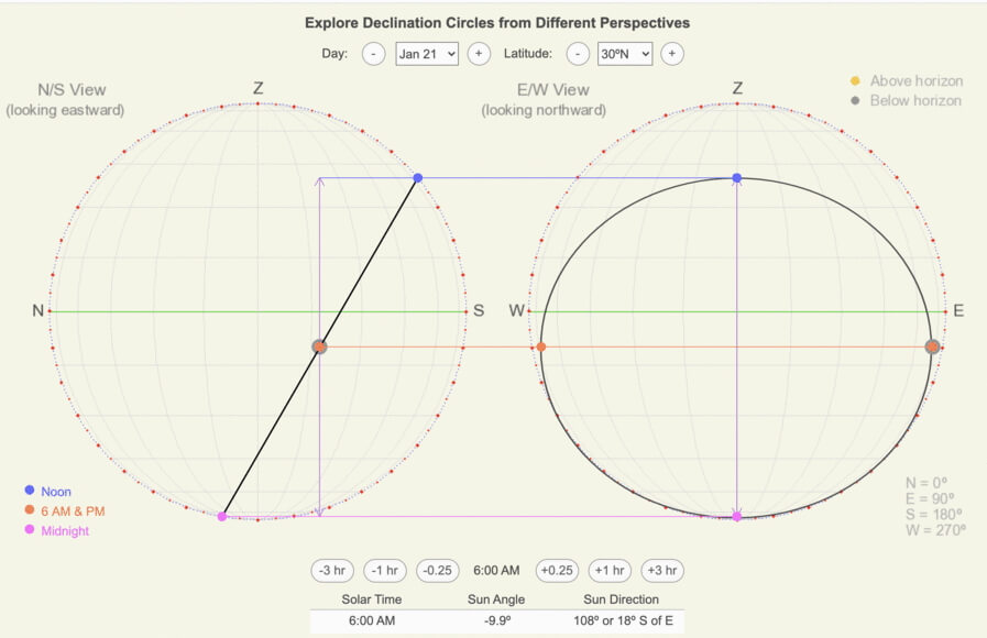
North/South and East/West-oriented declination circles for 30ºN on January 21 with the four key points, local noon, local midnight, and 6 AM and PM, connected with horizontal lines.
Go from N/S to Map View
To visually see the connection between the two circles, consider you are viewing the N/S view from far above the zenith. Notice that the 6 AM and PM points are halfway between the horizontal distance between local noon and midnight. Now it is easier to transfer the sun angle and directions of the four points from the N/S view to the map view circle. The key is that the white/light gray circles in the map view are the sun angle, which 0º the largest circle and 90º at the center.
Once these four points are positioned on the map view circle, you could sketch in the ellipse or find additional points to transfer from the N/S view, such as sunrise and sunset or the times halfway between 6 AM/PM and the corresponding noon and midnight times.
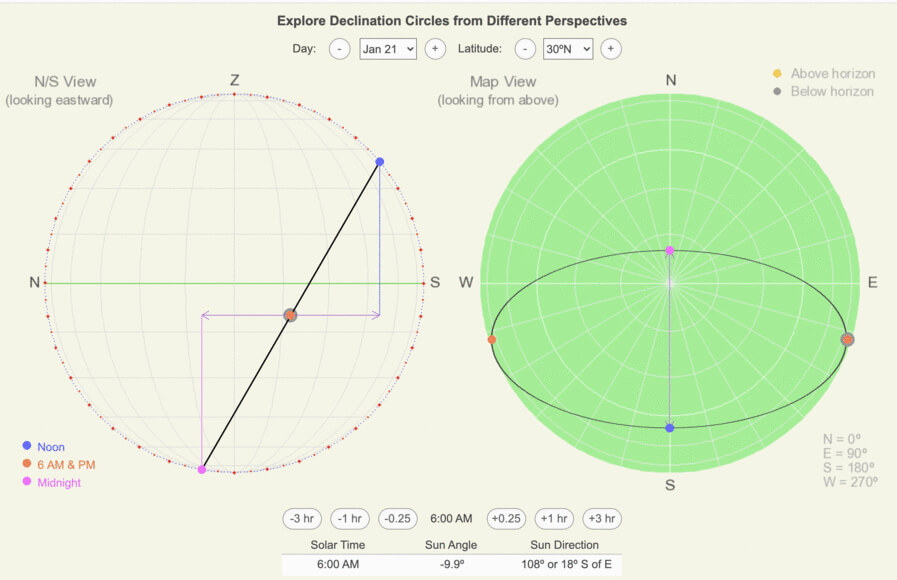
North/South-oriented and map view declination circles for 30ºN on January 21 with the four key points, local noon, local midnight, and 6 AM and PM, plotted. The short axis of the ellipse in the map view is half the horizontal distance between noon and midnight points on the N/S view (shown in purple).
Continue Exploring Declination Circles
Sun-Earth Connection desktop app has a section to drawing and interpreting declination circles. Explore declination circles for your latitude or your favorite time of year. Go to the Software page to download a version for Macs or PCs.
Big Ideas
- North/South-oriented declination circle is the easiest to draw and is easy to interpret sun angle throughout the day, but it is confusing to identify sun direction.
- East/West-oriented declination circles are especially useful to visualizing how to use or avoid the noontime sunlight.
- Map view declination circles are useful for navigating by the sun’s position throughout the day.
- Four key points quickly define the orientation and shape of a declination circle: local noon, local midnight, 6 AM, and 6 PM.
Click on the following toggles to view descriptions and links of the web pages on each topic of the Sun-Earth Connection.
Sun-Earth Connection overview
An overview of how the Sun’s energy is generated and how its thermal radiation illuminates and heats Earth.
Earth Illumination Patterns
- Overview: The Sun illuminates the spherical, rotating planets orbiting it.
- Obliquity and Earth’s Illumination: Obliquity is the angle between the planes of the Earth’s equator and its orbit around the Sun.
- Declination, Latitude, & Earth Illumination: Solar declination is the angle between the Sun’s rays and the plane of the Earth’s Equator. Its value depends on where Earth is in its orbit around the Sun.
- Astronomical Seasons & Illumination: Astronomical seasons are based on the orientation of Earth’s axis of rotation to the Sun, which determines the amount of illumination between the Northern and Southern Hemispheres.
Distribution of the Sun's Energy on Earth
- Overview: Even though an area is illuminated by sunlight, there can be quite a range of energy interacting with the surface.
- Sun Angle and Beam Concentration: If every beam of sunlight reaching Earth has the same amount of energy, why do some areas warm up more than others?
- Diurnal Heating: Diurnal heating is the temperature change over 24 hours. When sunlight shines on the ground, it warms. Two critical factors that determine the amount of heating deal with the Sun’s illumination.
- Seasons: Earth experiences astronomical seasons due to its obliquity.
- Climate Regimes: Climate regimes are an extension of diurnal heating and seasons, but the time frame is now years.
Declination Circles: A tool to analyze the Sun's position in the sky.
- Overview: Drawings of declination circles contain the visual and numerical information to understand and predict the Sun’s motion across the sky.
- Declination Circles 101: Draw a declination circle with just a ruler and protractor/compass to quickly and accurately know the Sun’s position in the sky at any day and time of the year for any location on Earth.
- Drawing Declination Circles: Declination circles are quite easy to draw by hand.
- Interpreting Time on Declination Circles: Accurately estimate the time of day using the Sun’s location in the sky.
- Sunrise, Sunset, & Twilight: Calculate the timing and duration when the Sun is at or near the horizon.
- Solar Time, Angle, & Position: The sun’s angle and direction to the local horizon define the Sun’s position in the local sky. Explore how to use declination circles to calculate the Sun’s position at any solar time anywhere in the world on any day of the year.
- Changing Views of Declination Circles: Use the web app View Declination Circles to explore three common views of declination circles to identify their strengths, limitations, and applications. Then learn how to go from one view to another.
- Using Declination Circles: Humans have been using the apparent motion of the Sun as a compass, clock, and calendar for millennia.
- Using Sundials: Humans have been using the Sun’s position to navigate and tell the time, day, and season for millennia. Sundials create shadows that make it easier to do these tasks.

0 Comments