
Declination, Latitude, & Earth Illumination
Solar declination is the angle between the Sun’s rays and the plane of the Earth’s Equator, and its value depends on where Earth is in its orbit around the Sun. On June 21, the summer solstice for the Northern Hemisphere, the northern end of the axis of rotation is pointing most directly toward the Sun, and the declination is 23.5º. On December 21, the winter solstice for the Northern Hemisphere, the axis of rotation is pointing away from the Sun, and the declination is -23.5º
Another way to think about declination is that it indicates the latitude with the most intense sunlight (beam concentration = 1) at local noon that day. During an equinox, March 21 or September 22, the solar declination (referred to as declination from here on) is 0º. Recall from Obliquity and Earth Illumination that the Sun was directly overhead at local noon for someone standing on the Equator during an equinox. On June 21, the local noon sun is directly overhead someone standing at 23.5ºN that day, and on December 21, 23.5ºS.

Animation of the Sun’s monthly illumination of Earth and the solar declination, the Sun’s angle from zenith at the Equator during local noon (shown in red).
Earth-Illumination Web App
To understand how Earth is illuminated by the Sun, start by viewing the Earth from space with the Earth-Illumination web app designed for desktops, laptops, and tablets.
The app has four visualizations for each month of the year:
-
- View the solar declination (shown in the animation above),
- View the astronomical seasons (solstices and equinoxes) and the solar declination,
- Compare the degree of illumination between the Northern and Southern Hemispheres, and
- Visualize which latitude experiences the Sun overhead at local noon.
Click the button above to run the web app.
Acknowledgments: Matti Horne provided invaluable insights, suggestions, and encouragement during the development of the Earth-Illumination app.
Is it a coincidence that the declination ranges between ±23.5º, where 23.5º is the Earth’s obliquity? Nope! The declination is based on where Earth is located within its orbit around the Sun and the orientation of the axis of rotation to the Sun. Recall from the previous page, Obliquity and Earth Illumination, our spinning planet is a gyroscope. Hence its axis of rotation stays fixed in one orientation even as it moves through space.
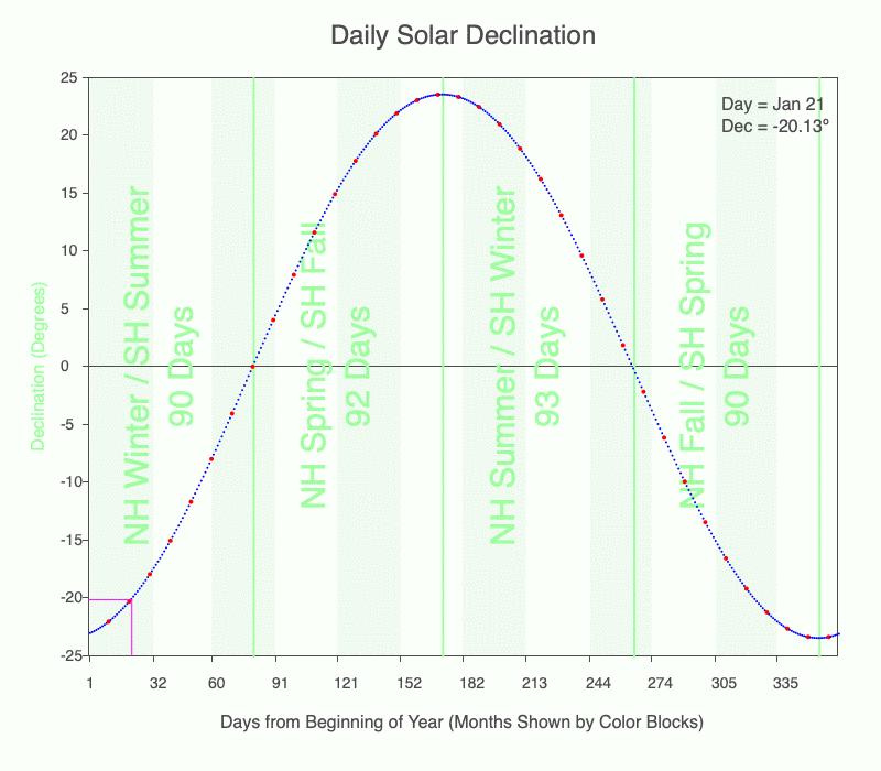
The following graph shows the cyclical pattern of how the declination changes each day of the year. Notice that the declination changes very slowly near the solstices and most quickly around the equinoxes. The pattern repeats itself each year.
Animation of the daily solar declination on the 21st of each month of the year. Every tenth day is marked with a red dot. Months are shown with alternating light green and white stripes. Darker green vertical lines mark the seasons. For an interactive graph of solar declination, download the Sun-Earth Connection desktop app on the Software page, or download a PDF to print.
Solar Declination Web App
Use the graph of daily solar declination to calculate:
-
- the declination for a given day,
- the day(s) for a given declination, and
- the change in declination for a range of days.
The Solar Declination app has three types of activities:
-
- Explore the connections between day, declination, and change in declination,
- Practice identifying these connections, and
- Quiz mode with less guidance to see how well you understand the connections.
For speed issues, the web app uses a simplified equation to calculate declination for each day of the year (a sine curve), but since Earth’s orbit is slightly elliptical, this introduces some errors. The PDF for download above takes into account the orbit’s eccentricity.
Click the button above to run the web app.

Animation of the Sun’s monthly illumination of Earth and the solar declination, the Sun’s angle from zenith at the Equator during local noon (shown in red).
Acknowledgments: Matti Horne provided invaluable insights, suggestions, and encouragement during the development of the Earth-Illumination app.
Big Ideas
- Solar declination is the angle between the Sun’s rays and the plane of the Earth’s Equator.
- An equinox occurs when the declination is 0º that day (March 21 and September 22, currently).
- A solstice occurs when the declination is ±23.5º (June 21 and December 21, currently).
- The range of solar declination is equal to the Earth’s obliquity.
Click on the following toggles to view descriptions and links of the web pages on each topic of the Sun-Earth Connection.
Sun-Earth Connection overview
An overview of how the Sun’s energy is generated and how its thermal radiation illuminates and heats Earth.
Earth Illumination Patterns
- Overview: The Sun illuminates the spherical, rotating planets orbiting it.
- Obliquity and Earth’s Illumination: Obliquity is the angle between the planes of the Earth’s equator and its orbit around the Sun.
- Declination, Latitude, & Earth Illumination: Solar declination is the angle between the Sun’s rays and the plane of the Earth’s Equator. Its value depends on where Earth is in its orbit around the Sun.
- Astronomical Seasons & Illumination: Astronomical seasons are based on the orientation of Earth’s axis of rotation to the Sun, which determines the amount of illumination between the Northern and Southern Hemispheres.
Distribution of the Sun's Energy on Earth
- Overview: Even though an area is illuminated by sunlight, there can be quite a range of energy interacting with the surface.
- Sun Angle and Beam Concentration: If every beam of sunlight reaching Earth has the same amount of energy, why do some areas warm up more than others?
- Diurnal Heating: Diurnal heating is the temperature change over 24 hours. When sunlight shines on the ground, it warms. Two critical factors that determine the amount of heating deal with the Sun’s illumination.
- Seasons: Earth experiences astronomical seasons due to its obliquity.
- Climate Regimes: Climate regimes are an extension of diurnal heating and seasons, but the time frame is now years.
Declination Circles: A tool to analyze the Sun's position in the sky.
- Overview: Drawings of declination circles contain the visual and numerical information to understand and predict the Sun’s motion across the sky.
- Declination Circles 101: Draw a declination circle with just a ruler and protractor/compass to quickly and accurately know the Sun’s position in the sky at any day and time of the year for any location on Earth.
- Drawing Declination Circles: Declination circles are quite easy to draw by hand.
- Interpreting Time on Declination Circles: Accurately estimate the time of day using the Sun’s location in the sky.
- Sunrise, Sunset, & Twilight: Calculate the timing and duration when the Sun is at or near the horizon.
- Solar Time, Angle, & Position: The sun’s angle and direction to the local horizon define the Sun’s position in the local sky. Explore how to use declination circles to calculate the Sun’s position at any solar time anywhere in the world on any day of the year.
- Changing Views of Declination Circles: Use the web app View Declination Circles to explore three common views of declination circles to identify their strengths, limitations, and applications. Then learn how to go from one view to another.
- Using Declination Circles: Humans have been using the apparent motion of the Sun as a compass, clock, and calendar for millennia.
- Using Sundials: Humans have been using the Sun’s position to navigate and tell the time, day, and season for millennia. Sundials create shadows that make it easier to do these tasks.
0 Comments