Distribution of the Sun’s Energy on Earth
Even though an area is illuminated by sunlight, there can be quite a range of how much energy is interacting with the surface. Two main factors determine how much radiation reaches the Earth’s surface:
-
- The intensity of the radiation (radiation per unit area per unit time) and
- The duration of sunlight illuminating the surface.

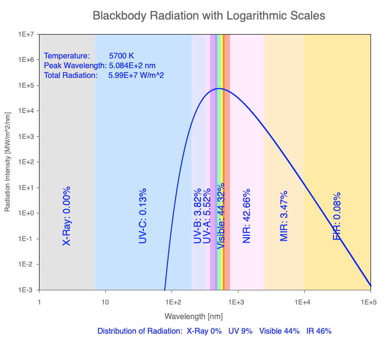
The electromagnetic spectrum emitted by our Sun. For more details, see diurnal heating over geologic time.
The Sun emits a relatively constant rate of radiation, so the intensity of the sunlight shining on a surface is the angle of the incoming beams relative to the surface. The lower the Sun is in the sky, the larger the area illuminated by a given beam of sunlight. The Sun’s energy is spread out over a larger area. The most concentrated sunlight occurs when the Sun is directly overhead. As we have seen in the previous section, Earth’s Illumination Patterns, the Sun is overhead at local noon for latitudes between the Tropic of Cancer (23.5°N) and the Tropic of Capricorn (23.5°S). Poleward of these latitudes, the Sun is never overhead.
The duration of sunlight at a location ranges from 0 hours to 24 hours during the day and is determined by two factors:
-
- Earth’s position within its orbit around the Sun, and
- The latitude, which determines the horizon’s orientation to the Sun.
Explore both at Declination, Latitude, and Earth Illumination.
This section will analyze graphs of calculations that incorporate these factors, but you may create many more using the desktop app, Sun-Earth Connection: download Mac or PC versions on the Software page.
In the section that follows this one, learn how to calculate the Sun’s angle in the sky and the duration of daylight using declination circles, which may be drawn with a ruler and protractor/compass.

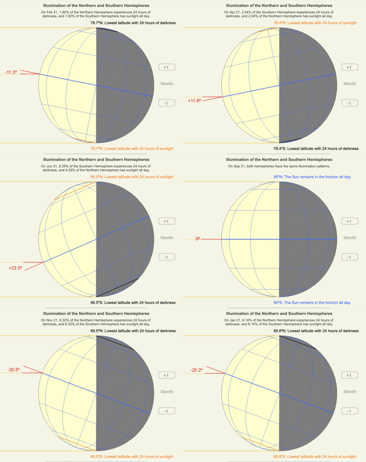
Animation of the uneven illumination of Earth’s northern and southern hemispheres throughout the year. Created using the web app, Earth Illumination, on Declination, Latitude, and Earth Illumination.
Although this section focuses on the distribution of the Sun’s energy on Earth, how warm will the surface actually become? The incoming radiation must be absorbed by the surface material and transformed to thermal energy, so the surface material properties come into play:
-
- Reflectivity,
- Specific Heat, and
- Density.
Consider how Earth has changed since it formed 4.5 billion years ago to see how Earth’s radiation budget has evolved.
Big Ideas
- The Sun’s energy heats the Earth unevenly to create its night/day heating patterns, seasons, and climate regimes, all of which maintain atmospheric and ocean currents.
- Earth’s orbit, rotation, and shape create the heating patterns.
Click on the following toggles to view descriptions and links of the web pages on each topic of the Sun-Earth Connection.
Sun-Earth Connection overview
An overview of how the Sun’s energy is generated and how its thermal radiation illuminates and heats Earth.
Earth Illumination Patterns
- Overview: The Sun illuminates the spherical, rotating planets orbiting it.
- Obliquity and Earth’s Illumination: Obliquity is the angle between the planes of the Earth’s equator and its orbit around the Sun.
- Declination, Latitude, & Earth Illumination: Solar declination is the angle between the Sun’s rays and the plane of the Earth’s Equator. Its value depends on where Earth is in its orbit around the Sun.
- Astronomical Seasons & Illumination: Astronomical seasons are based on the orientation of Earth’s axis of rotation to the Sun, which determines the amount of illumination between the Northern and Southern Hemispheres.
Distribution of the Sun's Energy on Earth
- Overview: Even though an area is illuminated by sunlight, there can be quite a range of energy interacting with the surface.
- Sun Angle and Beam Concentration: If every beam of sunlight reaching Earth has the same amount of energy, why do some areas warm up more than others?
- Diurnal Heating: Diurnal heating is the temperature change over 24 hours. When sunlight shines on the ground, it warms. Two critical factors that determine the amount of heating deal with the Sun’s illumination.
- Seasons: Earth experiences astronomical seasons due to its obliquity.
- Climate Regimes: Climate regimes are an extension of diurnal heating and seasons, but the time frame is now years.
Declination Circles: A tool to analyze the Sun's position in the sky.
- Overview: Drawings of declination circles contain the visual and numerical information to understand and predict the Sun’s motion across the sky.
- Declination Circles 101: Draw a declination circle with just a ruler and protractor/compass to quickly and accurately know the Sun’s position in the sky at any day and time of the year for any location on Earth.
- Drawing Declination Circles: Declination circles are quite easy to draw by hand.
- Interpreting Time on Declination Circles: Accurately estimate the time of day using the Sun’s location in the sky.
- Sunrise, Sunset, & Twilight: Calculate the timing and duration when the Sun is at or near the horizon.
- Solar Time, Angle, & Position: The sun’s angle and direction to the local horizon define the Sun’s position in the local sky. Explore how to use declination circles to calculate the Sun’s position at any solar time anywhere in the world on any day of the year.
- Changing Views of Declination Circles: Use the web app View Declination Circles to explore three common views of declination circles to identify their strengths, limitations, and applications. Then learn how to go from one view to another.
- Using Declination Circles: Humans have been using the apparent motion of the Sun as a compass, clock, and calendar for millennia.
- Using Sundials: Humans have been using the Sun’s position to navigate and tell the time, day, and season for millennia. Sundials create shadows that make it easier to do these tasks.

0 Comments