
← Seasons | Declination Circles →
Climate Regimes
Climate regimes are an extension of diurnal heating and seasons, but the time frame is now years. We are looking at the repeating seasonal temperature patterns that develop in response to yearlong changes in declination. There are three latitudinal climate bands: the tropics, midlatitudes, and polar regions.
To explore how temperature changes throughout the year, we will examine the total daily solar energy trends. This value incorporates the number of daylight hours and how high the Sun is above the horizon throughout the day.
Tropics
The tropics are characterized by consistently warm to hot seasons throughout the year. There is little change in the number of hours of daylight and the local noon sun angle. Combining the two steady variables create a near-constant supply of solar energy throughout the year.
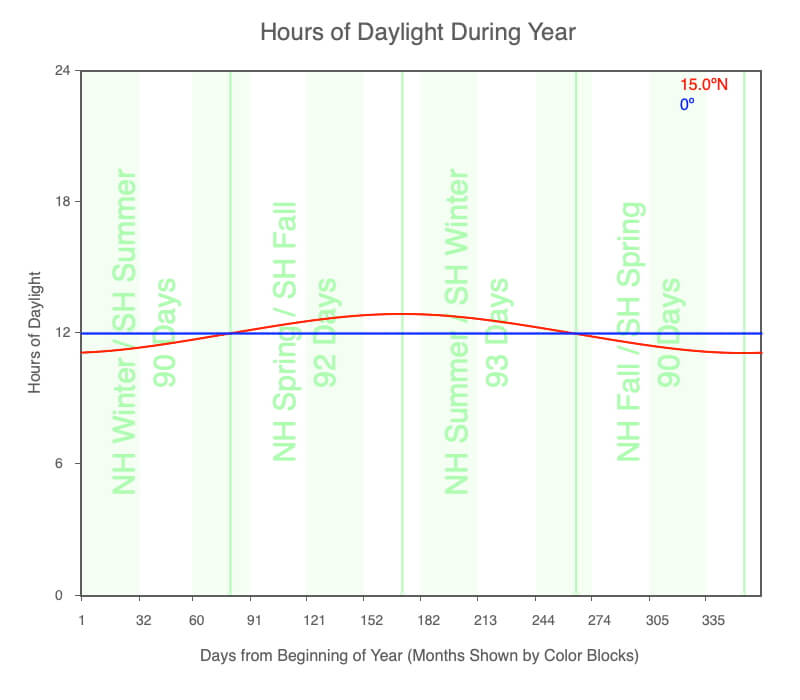
The number of daylight hours throughout the year for the equator and 15ºN.
Declination circles are close to perpendicular in low latitudes, which creates very little change in the number of hours of daylight throughout the year. At the equator, every day experiences 12 hours of daylight.
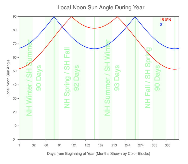
The angle of the local noon sun above the horizon throughout the year for the equator and 15ºN.
Low latitudes experience the Sun directly overhead at local noon at some time of the year. Between 23.5ºN (the Tropic of Cancer) and 23.5ºS (the Tropic of Capricorn), the Sun is directly overhead twice a year. At these particular latitudes, the Sun is directly overhead during the hemisphere’s summer solstice.
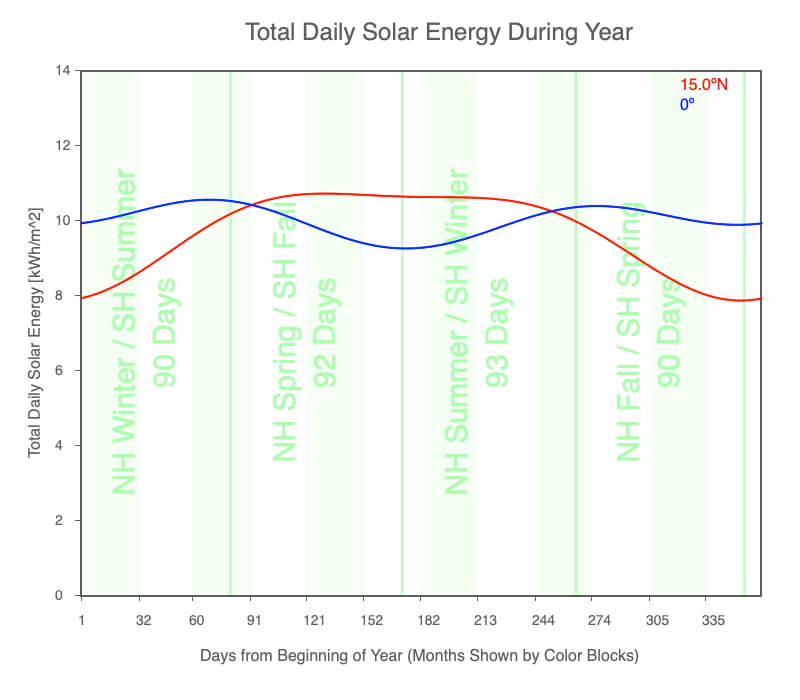
The total daily solar energy received throughout the year at the equator and 15ºN.
Since both hours of daylight and high beam concentration are consistent throughout the year, the tropics receive a steady, intense solar radiation. The hot tropics stretch across the low latitudes of the globe.
Midlatitudes
The midlatitudes have warm to hot summers, rapidly changing temperature patterns during fall and spring, and cold winters. These variable seasonal conditions are created through large changes in the duration of daylight and local noon sun angle during the year.
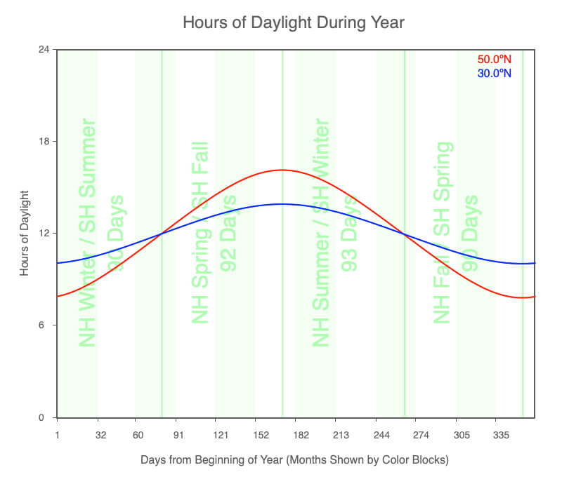
The number of daylight hours throughout the year for the 30ºN and 50ºN.
Declination circles are moderately steep, which creates considerable change in the number of hours of daylight throughout the year.
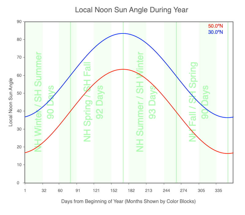
The angle of the local noon sun above the horizon throughout the year for the 30ºN and 50ºN.
Due to the declination circles’ orientation, the local noon sun angle changes by twice the obliquity (2 x 23.5° = 47º) during the year. For example, the local noon sun angle for 45ºN on June 21 is 78.5º, and on December 21, it is 21.5º.
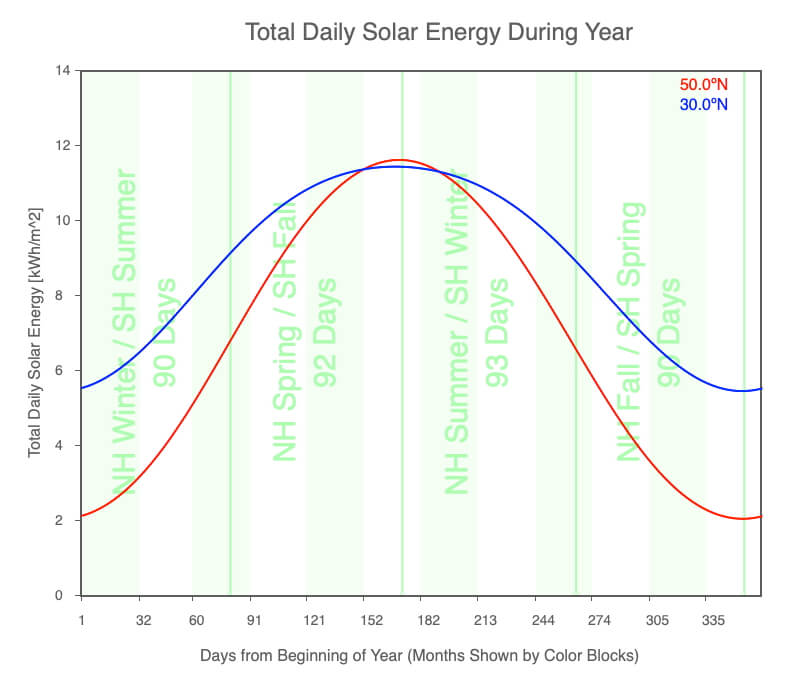
The total daily solar energy received throughout the year at the 30ºN and 50ºN.
Notice that the total daily solar energy during the summer is actually greater than in the tropics, but the winter months experience much less solar radiation.
Since both the hours of daylight and beam concentration are quite variable during the year, seasonal temperatures change considerably.
Polar Regions
The polar regions are characterized by bitterly cold, dark winters and cold to warm summers, depending on the reflectance of the surface.
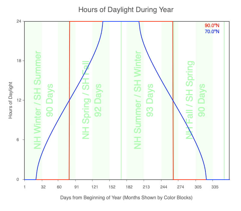
The number of daylight hours throughout the year for the 70ºN and 90ºN, the North Pole.
Declination circles are near parallel to the horizon, which creates extreme change in the number of hours of daylight throughout the year — the North Pole experiences six months of darkness followed by six months of sunlight.
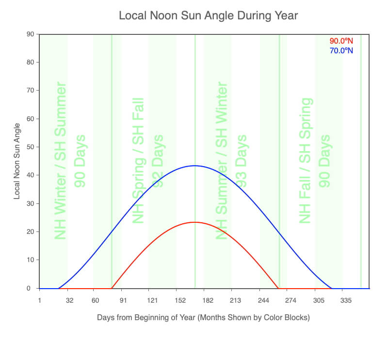
The angle of the local noon sun above the horizon throughout the year for the 70ºN and 90ºN.
The local noon sun angle for all latitudes changes by twice the obliquity during the year. But in the polar regions, the local noon sun angle goes below the horizon for part of the year. When the Sun is above the horizon, it remains relatively low in the sky.
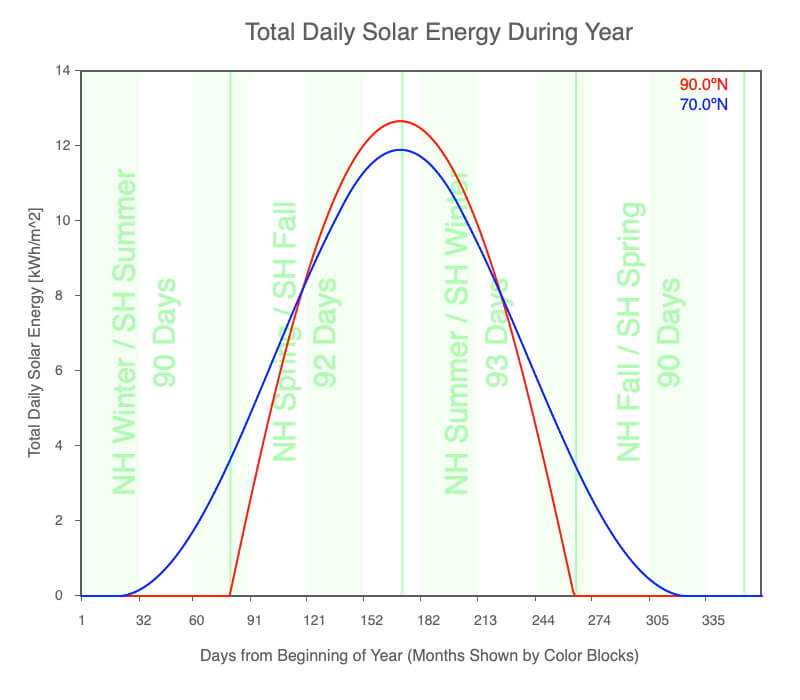
The total daily solar energy received throughout the year at the 70ºN and 90ºN.
Notice that the total daily solar energy during the summer is more substantial than the tropics, but the winter months experience no solar radiation.
If the surface is highly reflective, such as snow and ice, the summer months remain cold. But if the ground is highly absorbent, such as rock and water, the temperatures can increase considerably during this period of consistently high solar radiation.
Where Are the Boundaries Between the Climate Regions?
So the tropics, midlatitudes, and polar regions exist, but where are their boundaries located? Examining the annual range of variables by latitude for the three key components that create the climate regions, the boundaries are gradual. Since they are, other factors that influence a given region’s energy budget may alter the local climate. These factors include the presence of large water bodies, extensive vegetation (forests and grasslands), mountains, thick deposits of snow and ice, warm/cold wind patterns, and warm/cold ocean currents.
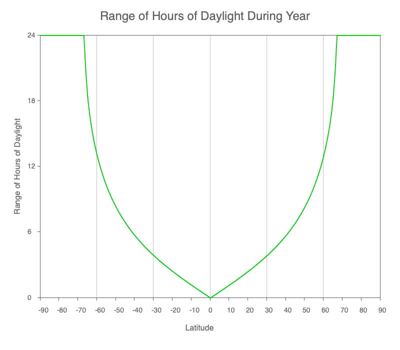
Graph of the annual range of daylight hours by latitude.
The equator always experiences 12 hours of daylight each day, and so has a range of 0 hours. The range of daylight hours increase away from the equator, and by 66.5º latitude, there are days without sunlight and darkness during the year. The Arctic Circle is 66.5ºN, and 66.5ºS is the Antarctic Circle.
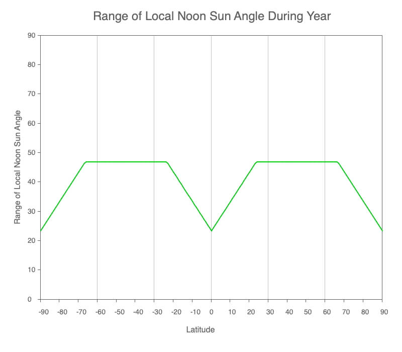
Graph of the annual range of the local noon sun angle above the horizon by latitude.
Between 23.5ºN and 23.5ºS, the sun is overhead at local noon at some time of the year. The changing solar declination does not create as much change in local noon sun angle between these latitudes since the Sun passes overhead, allowing the angle to remain higher.
The latitudes between 23.5º and 66.5º experience the full impact of the changing solar declination during the year (2 x 23.5º = 47º).
At and poleward of 66.5º latitude, the Sun moves below the horizon for extended times. If the Sun is 10º below the horizon, the local noon sun angle is 0º. These high latitudes experience low sun angles when the Sun is above the horizon.
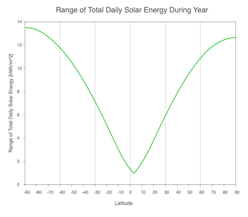
Graph of the annual range of total daily solar energy received by latitude.
The equatorial region, or tropics, receives the most consistent amount of sunlight throughout the year, hence the consistently high seasonal temperatures. If the polar l latitudes were not covered by snow and ice and did not get so cold during their extended darkness, the amount of sunlight they receive could make these regions very warm during the summer.
The northern polar region has a larger range in daily solar energy compared to the southern counterpart. There is also less of an annual difference of daily solar radiation just south of the equator compared to 0º.
It turns out Earth’s orbit around the Sun is not perfectly circular, rather it is slightly elliptical. Earth’s distance to the Sun changes during the year, which changes the intensity of sunlight reaching us. This property of our orbit, the eccentricity, will be explored in detail in Star-Planet Connection.
Big Ideas
- Climate regimes are based on the repeating seasonal temperature patterns that develop in response to yearlong changes in declination and a region’s latitude.
- There are three latitudinal climate bands: the tropics, midlatitudes, and polar regions.
- The tropics are characterized by consistently warm to hot seasons throughout the year.
- The midlatitudes have warm to hot summers, rapidly changing temperature patterns during fall and spring, and cold winters.
- The polar regions are characterized by bitterly cold, dark winters and cold to warm summers, depending on the surface’s reflectance.
← Seasons | Declination Circles →
Click on the following toggles to view descriptions and links of the web pages on each topic of the Sun-Earth Connection.
Sun-Earth Connection overview
An overview of how the Sun’s energy is generated and how its thermal radiation illuminates and heats Earth.
Earth Illumination Patterns
- Overview: The Sun illuminates the spherical, rotating planets orbiting it.
- Obliquity and Earth’s Illumination: Obliquity is the angle between the planes of the Earth’s equator and its orbit around the Sun.
- Declination, Latitude, & Earth Illumination: Solar declination is the angle between the Sun’s rays and the plane of the Earth’s Equator. Its value depends on where Earth is in its orbit around the Sun.
- Astronomical Seasons & Illumination: Astronomical seasons are based on the orientation of Earth’s axis of rotation to the Sun, which determines the amount of illumination between the Northern and Southern Hemispheres.
Distribution of the Sun's Energy on Earth
- Overview: Even though an area is illuminated by sunlight, there can be quite a range of energy interacting with the surface.
- Sun Angle and Beam Concentration: If every beam of sunlight reaching Earth has the same amount of energy, why do some areas warm up more than others?
- Diurnal Heating: Diurnal heating is the temperature change over 24 hours. When sunlight shines on the ground, it warms. Two critical factors that determine the amount of heating deal with the Sun’s illumination.
- Seasons: Earth experiences astronomical seasons due to its obliquity.
- Climate Regimes: Climate regimes are an extension of diurnal heating and seasons, but the time frame is now years.
Declination Circles: A tool to analyze the Sun's position in the sky.
- Overview: Drawings of declination circles contain the visual and numerical information to understand and predict the Sun’s motion across the sky.
- Declination Circles 101: Draw a declination circle with just a ruler and protractor/compass to quickly and accurately know the Sun’s position in the sky at any day and time of the year for any location on Earth.
- Drawing Declination Circles: Declination circles are quite easy to draw by hand.
- Interpreting Time on Declination Circles: Accurately estimate the time of day using the Sun’s location in the sky.
- Sunrise, Sunset, & Twilight: Calculate the timing and duration when the Sun is at or near the horizon.
- Solar Time, Angle, & Position: The sun’s angle and direction to the local horizon define the Sun’s position in the local sky. Explore how to use declination circles to calculate the Sun’s position at any solar time anywhere in the world on any day of the year.
- Changing Views of Declination Circles: Use the web app View Declination Circles to explore three common views of declination circles to identify their strengths, limitations, and applications. Then learn how to go from one view to another.
- Using Declination Circles: Humans have been using the apparent motion of the Sun as a compass, clock, and calendar for millennia.
- Using Sundials: Humans have been using the Sun’s position to navigate and tell the time, day, and season for millennia. Sundials create shadows that make it easier to do these tasks.
0 Comments