← Coordinate System | Energy →
A Sundial as a Clock, Compass, and Calendar
Earth’s axis of rotation orients our coordinate system of latitude and longitude. Since Earth is a rotating sphere that orbits the Sun, our source of light, Earth’s latitude and longitude are connected to the Sun’s illumination of Earth. The Sun’s position in the sky tells us time, direction, and location in our orbit. A sundial lets us track the Sun’s movement throughout the day and year, turning it into a clock, compass, and calendar.
There are many types of sundials, but we will focus on the simplest: a vertically standing object. These frequently occur in nature: trees! Humans tend to erect vertical buildings, not ones that tilt (the Tower of Pisa was an accident!). And if we stand in a flat field with no trees or buildings, we may use our shadow. So we can apply these simple sundials to tell time, find our way, and prepare for the upcoming seasons any place where the Sun is shining on Earth.
To create shadow traces for any latitude at any time of the year, click on the button above to run the free web app, Sundial Shadows. There is considerable supporting information on how to interpret sundial shadows below – and there is a second button to run the app.
Key Terms and Concepts to Apply
- North and south point in the direction of the local longitude meridian (a half circle), which is toward the axis of rotation.
- East and west point in the direction of the local latitude circle.
- Shadows are always opposite to the Sun’s position in the sky.
- The shortest shadow occurs when the Sun is highest in the sky.
- The longest shadow occurs when the Sun appears on the horizon, so during sunrise and sunset.
- The movement of shadows before local noon is symmetric to those observed after local noon. The time of the shortest shadow occurs halfway between sunrise and sunset. This time is called local noon.
- Because the Sun is crossing the local longitude at local noon, the shadow will either point directly north or south or will not be seen if the Sun is directly overhead.
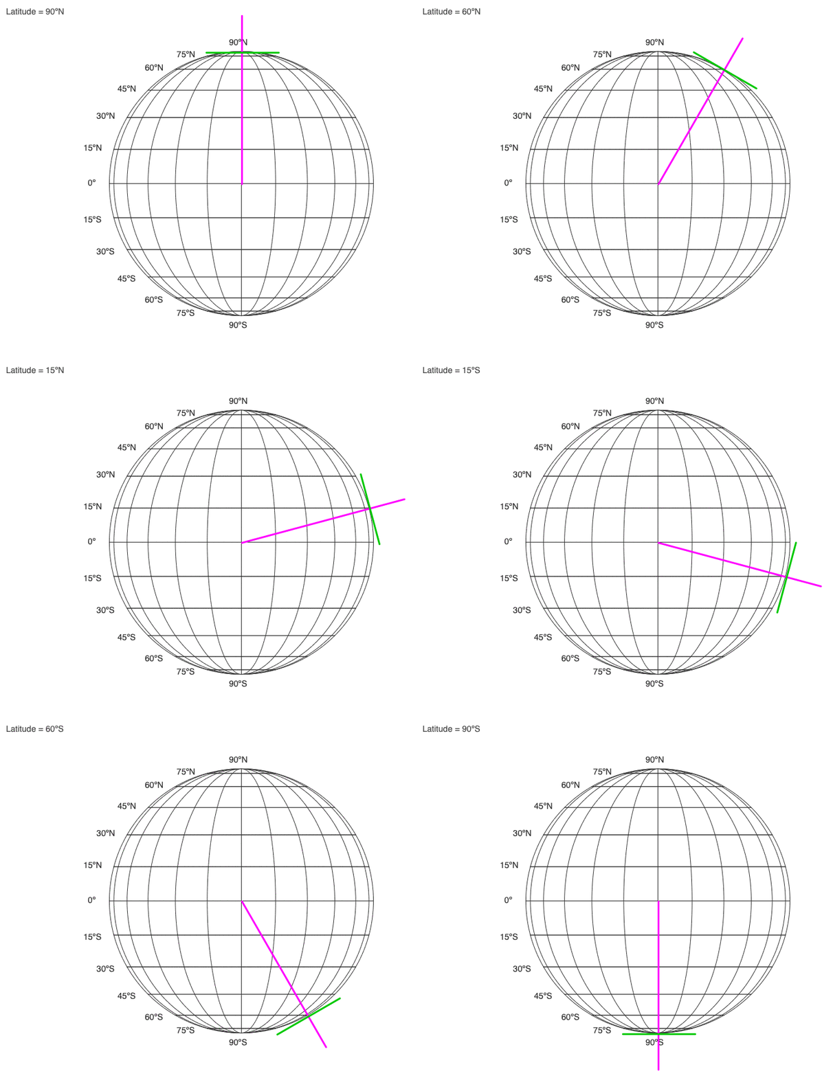
A vertical object points toward its zenith (magenta line extending from the Earth’s surface), and as latitude changes, the orientation of the horizon (green line) and zenith change relative to the axis of rotation. Since shadows point away from the Sun, a vertical object will cast a shadow of different lengths and orientations for the same time of day, depending on the latitude.
Build and Use A Sundial
Although this may seem like a simple activity, tracking shadows cast by a vertical pole provides insightful experiences of the daily and seasonal patterns of solar illumination for a given latitude. Very few of us take the time to watch shadows move, let alone mark, measure, and use them to understand our natural world. Plus, nothing beats a bit of hands-on science!
Tip 1: Before running the activity, check the weather forecast for cloud cover – clear skies are best to run this activity, and preferably for two consecutive days.
Tip 2: Any vertical pole with level ground around it works well, such as a tetherball pole on the pavement. Use colored chalk to mark the shadows.
Preparation
This activity needs to run from the morning into the afternoon in order to see the pattern of the Sun’s motion and use the data to measure the direction of true north and calculate when local noon occurred (clock time is different from Sun time). Set up the sundial and begin taking measurements and marking with the colored yarn by 10 AM at the latest. Pick a location with adequate availability of open sky above and around the post.
Materials
- 5-8 foot length of 2 to 4-inch diameter PVC pipe
- at least 20 feet of sturdy, flexible rope
- at least 4 stakes
- drill and bit (larger than rope’s diameter)
- hammer or mallet
- vertical level
- 4 tent stakes
- 10 to 15 sturdy plastic labels/stakes, similar to those used for marking plants in the garden (label with time); consider more labels/ stakes if using a longer time interval
- 3 or 4 spools of colored yarn or string if working on grass or soil; colored chalk if working on pavement
- level ground
Procedures
Every 10-15 minutes, mark the position of the end of the shadow with a marker. Secure the tag in the ground. To help visualize past shadows, connect colored yarn between the tag and the base of the PVC pipe. Local noon is the time of day when the Sun is highest in the sky, and the shadow will be the shortest. Local noon occurs when the Sun is due south of the observer if you are north of 23.5ºN latitude, so the shadow at local noon points toward true north. If you are south of 23.5ºS, then the Sun’s position at local noon will always be due north of you. Between the Tropic of Cancer (23.5ºN) and Tropic of Capricorn (23.5ºS), the Sun will either be directly overhead, due north or due south of you depending on the time of year.
Building
- Drill 4 holes in the middle of the PVC pipe.
- Thread 10′ of rope through two of the holes, then another 10′ of rope through the remaining two holes.
- While holding the pipe vertical (helpful to have another person helping), stake the ends of the rope to the ground.
- Build/install the sundial as early as possible in the morning (or the day before, if an option), so measurements may start early in the morning, 10 AM at the latest.
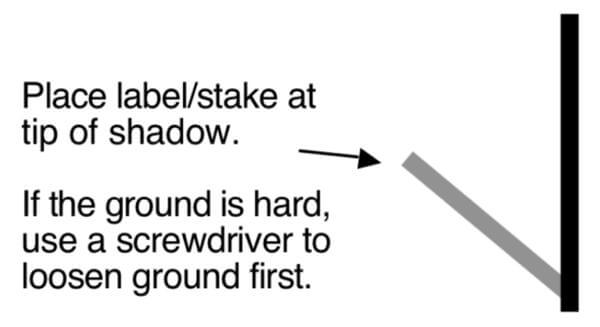
Clock Time versus Sun Time
Being in Boston, with a longitude of 72ºW, we are very close to the eastern edge of the Eastern Time zone, and our local noon is nearly an hour before to that experienced by someone close to the western edge of the Eastern Time zone. The eastern side of a time zone experiences sunrise, local noon, and sunset an hour earlier than the west edge of that time zone. Remember, we use standard time during the winterish months and daylight savings time during the summerish months, so local noon may occur after 1 PM, depending on your location and day of the year. By marking shadow positions every 10-15 minutes, you will be able to calculate the time of local noon and where true north is oriented. Look at the trace of the shadows and notice that they were long in the morning, became shortest around noon, and then got long in the afternoon. The key is that the shadows’ lengths are symmetric about the shortest shadow.
Finding the Clock Time of Local Noon
Use the circle, shadow trace, and intersections described below to calculate the time of local noon:
1) Estimate the time the trace of the shadow (orange) first crosses the circle (black). In this example, it appears to be near 10:15 AM.
2) Estimate the time the shadow moved outside the circle. For this example, it appears to be near 12:45 PM.
3) The midpoint between these two times is the clock time of local noon:
(10:15 + 12:45) / 2 = 23 / 2 = 11:30 AM
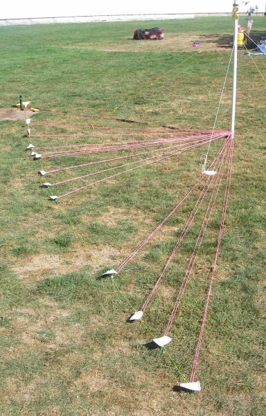
Use colored yarn if on grass or colored chalk if on pavement to mark individual shadows and to connect the tips of the shadows.
Suggestions
If you are running this activity at school, it works great if there are multiple classes working on it through the day making measurements. Learn how to use it as a clock, compass, and a calendar after a day of data collecting. If a single class did the activity, I gave homework to work in teams to make measurements throughout the school day.
If you have a block of time to spend at the sundial, bring additional tools with you. A globe (or a ball and chalk to mark on the ball), compass, pencil and notebook/drawing pad are good. Use the globe/ball to help visualize why the Sun appears to be moving as it is for your location – and any location on Earth. Also, explore how latitude and longitude come into play with the direction and timing of the motion of the Sun. For example, was sunrise north of east, east, or south of east that morning? Why is the Sun south of you at local noon (if you are north of 23.5ºN)? Where would it be if you were south of 23.5ºS?
Excellent Earth Day Activity
I have run this for a number of years in local parks during Earth Day, and it is a hit with all ages! Since so many aspects of our lives are driven by the Sun’s energy, learning about the daily and seasonal patterns of this energy source relates to the Earth Day theme.
Finding Local Noon and True North Using a Shadow Trace
True north points to the axis of the Earth’s rotation. At all latitudes north of 23.5ºN, the direction of the shortest daily shadow points toward true north. To find the exact direction of the shortest shadow:
1) Using a string tied to the base of the sundial, create a circle (black) from the center post
2) Mark where the trace of the shadows (orange line) crosses the circle (blue line).
3) Find the midpoint of the blue line (place a string along the blue line and fold it in half) and extend the green line from the center post through this point. The green line is pointing true north.
Using a compass, compare true north to magnetic north in your location. This is a valuable mini-experiment that will be used to explore what creates Earth’s magnetic field. The difference between true north and magnetic north is the magnetic declination.
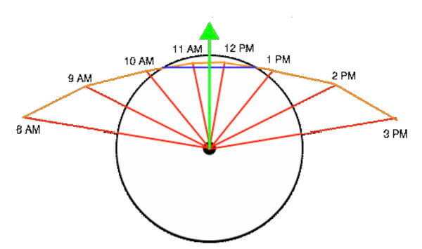
Above is an illustration on how to find true north (green arrow) using the daily trace of shadows from a sundial (orange “curve”).
Using a Sundial as a Calendar
If you can save the markings, run this activity every week or two and compare the differences in the location and shape of the shadow trace (orange line above). If you are after December 21 and before June 21, the shadows get closer to the sundial each day. And between June 21 and December 21, the shadows move away from the sundial each day. If you have saved each week’s shadow trace, you have a calendar!
To create shadow traces for any latitude at any time of the year, click on the button above to run the free web app, Sundial Shadows.
Sundial Shadow Traces Throughout the Year
Local noon is when the Sun is at its highest point in the sky. The Sun crosses your longitude at local noon, so it is precisely north, south, or overhead at that moment. Because the Sun is highest in the sky, the shadows are shortest, and they point in the opposite direction from the Sun. Finally, the shadow patterns are symmetric about local noon. The shadow length an hour before local noon is the same as that an hour later, and the direction pointing away from the local noon shadow is the same an hour before and after local noon.
Two latitudes don’t experience local noon: the North and South Poles. Why?
Each of these ways to think about local noon are important for navigation, telling the time of day and the day of the year, using solar panels and other solar-based technologies, building energy-efficient buildings, gardening, and understanding the seasons and climate regimes.
What patterns do you see for the daily shadows at 42.5ºN change throughout the year?
1) The shadows are symmetric around local noon, which is when the Sun is precisely south of the sundial at 42.5ºN.
2) The Sun is never overhead at local noon at any time during the year at 42.5ºN. The Sun’s angle above the horizon at local noon changes throughout the year.
3) The Sun only rises east of the sundial twice a year (during the equinoxes). Half the year (minus a day), the Sun rises north of east (spring and summer), and the other half minus a day, south of east (fall and winter).
4) During the year, the locations of the shadows change most toward sunrise and sunset and least at local noon.
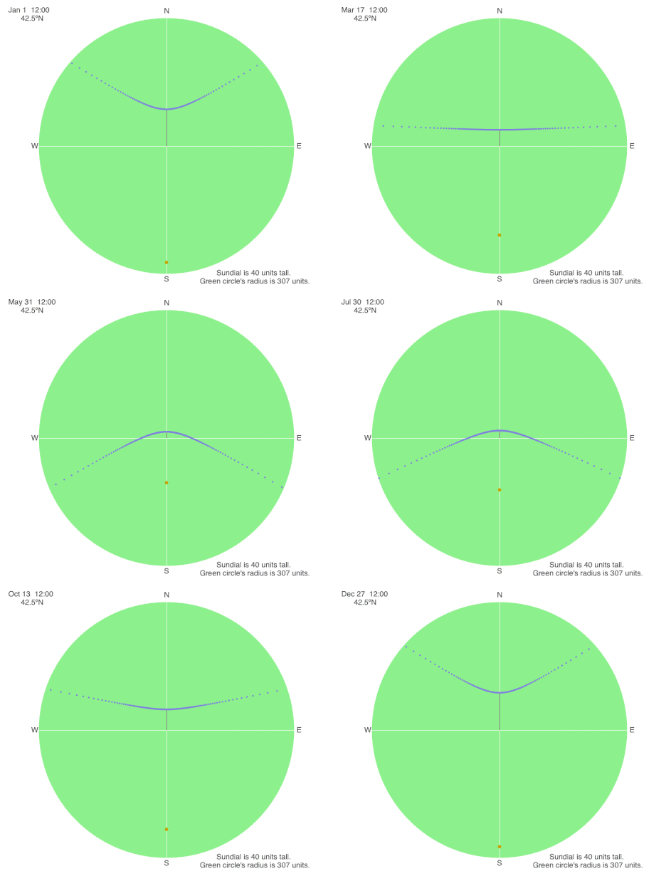
In this animation of the daily shadows for 42.5ºN every two weeks of the year, the blue dots represent the tips of the sundial’s shadow every 4 minutes, and the black line is the sundial’s shadow at local noon. The orange circle is the Sun’s position from zenith at local noon.
Extension: Calculating the Altitude of the Sun in the Sky
You need to be familiar with the tangent function (see Right Triangles and Vectors).
If you measure the angle of the sun at local noon during an equinox (March 21 or September 21), you may calculate your latitude.
Latitude = 90º – local noon sun angle
For other days of the year, if you are north of 23.5ºN:
Latitude = 90º – local noon sun angle + solar declination
Solar declination depends on the day of the year.
To explore the Sun’s illumination patterns of Earth, see the Sun-Earth Connection, and for more detail on solar declination, see Declination, Latitude, and Solar Illumination.
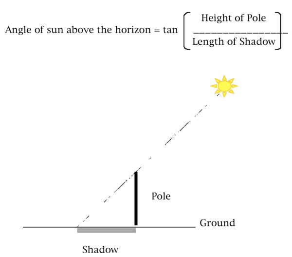
Above is an illustration of how to calculate the angle of the Sun above the horizon. Use this calculation at any time of day.
For more information using sundials and a free web app to explore a sundial’s shadows at any latitude, date, and time of year, see Using Sundials.
Big Ideas
- There are two forms of time.
- Sundials measure nature’s time that is defined by the Sun’s apparent movement across the sky.
- Clocks measure human time created for our business, communications, and transportation needs.
- Use a sundial as a calendar of the seasons and as a compass too.
← Coordinate System | Energy →

This is my first time to see and read about how sundials work.
I’ll be 85 in August, and I have never seen the basics explained.